Island Stories:
![]() Danzig
Mine
Danzig
Mine
![]() Zeballos
Iron Mine
Zeballos
Iron Mine
![]() Conuma
Peak 1910
Conuma
Peak 1910
Alexandra Peak
Argus Mountain
Bate/Alava Sanctuary
Beaufort Range
Big Interior Mtn
Big Interior Mtn 1913
Part 1
Part 2
Bolton Expedition 1896
Cliffe Glacier
Clinton Wood
Comox Glacier
Comox Glacier 1922
Comox Glacier 1925
Comstock Mtn
Conuma Peak
Copper King Mine
Crown Mtn
Elkhorn 1912
Elkhorn 1949
Elkhorn 1968
Eugene Croteau
Golden Bullets
Golden Hinde 1913/14
Golden Hinde 1937
Golden Hinde 1983
Harry Winstone Tragedy
Jack Mitchell
Jim Mitchell Tragedy
John Buttle
Judges Route
Koksilah's Silver Mine
Landslide Lake
Mackenzie Range
Malaspina Peak
Mariner Mtn
Marjories Load
Matchlee Mountain
Mount McQuillan
Mt. Albert Edward
Mt. Albert Edward 1927
Mt. Albert Edward 1938
Mt. Becher
Mt. Benson 1913
Mt. Benson
Mt. Doogie Dowler
Mt. Colonel Foster
Mt. Hayes/Thistle Claim
Mt. Maxwell
Mt. Sicker
Mt. Tzouhalem
Mt. Whymper
Muqin/Brooks Peninsula
Nine Peaks
Queneesh
Ralph Rosseau 1947
Rosseau Chalet
Ralph Rosseau Tragedy
Rambler Peak
Red Pillar
Rex Gibson Tragedy
Sid's Cabin
Steamboat Mtn
Strathcona Park 1980's
The Misthorns
The Unwild Side
Victoria Peak
Waterloo Mountain 1865
Wheaton Hut/Marble Meadows
William DeVoe
Woss Lake
You Creek Mine
Zeballos Peak
Other Stories:
Sierra
de los Tuxtlas
Antarctica
Cerro del Tepozteco
Citlaltepetl
Huascaran
Mt. Roraima
Nevada Alpamayo
Nevada del Tolima
Nevado de Toluca
Pico Bolivar
Popocatepetl
Uluru/Ayers Rock
Volcan Purace
Volcan San Jose
Biographies
Island 6000
Cartoons
Order the Book
Contact Me
Links

The
Comox Glacier:
And
its Early Climbing History
by Lindsay Elms
 In
a symbolic sense one could say that the Comox Valley of Vancouver Island
has a connection to the Kathmandu Valley of Nepal, albeit different religions
prosper, however, they both have someone watching over them. Above Kathmandu
at the Swayambanath Temple the eyes of Buddha watch over the valley and
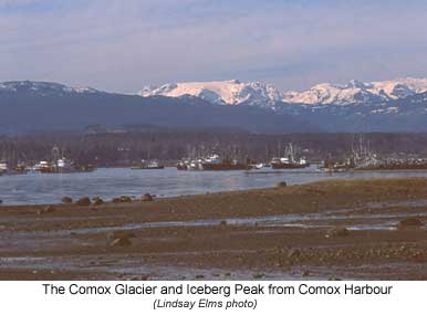
people, while above the Comox Valley there is Queneesh
- the great white whale or, as most people know it, the Comox Glacier.
The glacier is a large, perpetual sheet of frozen water curling and grinding its way over the top of the mountains the way a fog bank sweeps in over the ocean enveloping everything in its path. In summer it is a popular destination for hikers and climbers, while in the winter months a thick mantle of new snow adds many metres to the bulk of the glacier, making it a beautiful backdrop for those skiing on Mount Washington.
The Comox Glacier has been attracting mountaineers since the 1920's with the first recorded European party being lead by the enigmatic Reverend George B. Kinney. Kinney was an experienced mountaineer whose name is associated with "the Monarch of the Rockies" Mount Robson. Between 1906 and 1908 Kinney attempted the unclimbed Mount Robson numerous times and when he returned in August 1909, he was more determined then ever to reach its summit as there were rumours that "foreign parties had designs on the mountain." Kinney teamed up with twenty-five- year-old Donald "Curly" Phillips and made a number of attempts before finally claiming to have reached the summit of Mount Robson on August 13. However, following the 1913 ascent by Conrad Kain, Kinney was discredited with the first ascent and isolated from the climbing community. Right from the beginning there was amazement and incredulity that Kinney, without Swiss guides and accompanied by a cowboy who didn't even have an ice axe, could succeed on such a difficult mountain.
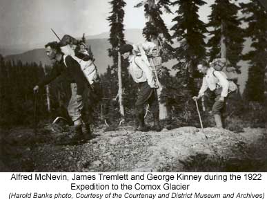
In June 1920 Kinney took a position as minister at the Grace Methodist Church in Cumberland and it was there he first saw the Comox Glacier. Two years later Kinney heard that Harold Banks was organizing an expedition to cross the glacier to Buttle Lake and he asked if he could join. On August 16, 1922 with Alfred McNevin, James Tremlett and Harold Banks, Kinney set out to scale the glacier. Their route from Courtenay took them up the Puntledge River to Comox Lake and then to the head of the lake by boat. They continued up the Puntledge River to First Trout (Willemar) Lake and onto Second and Third Trout (Forbush) Lake. From here they hiked up onto Mount Evans (Kookjai Mountain) and camped at Ester (Tatsno) Lake, then went over what became known as Blackcat Mountain, down to Lone Tree Pass and finally up to the glacier. On the summit they built a rock cairn to mark their ascent. They then continued down to Crystle (Mirren) Lake and climbed up onto the Aureole Snowfield, summiting several of the surrounding peaks. Finally they dropped into Shepherd Creek and followed it down to Buttle Lake. Here they built a raft on which they travelled down the lake until some tourists picked them up in their boat. After ten days they reached Campbell River where Harold Bank's father picked them up and drove them back to Cumberland, exhausted but triumphant.
George Kinney stayed in Cumberland for another year before being assigned to the tiny coastal community of Ocean Falls. He retired from the services of the church in 1942 and passed away in Victoria in 1961 at the age of eighty-nine.
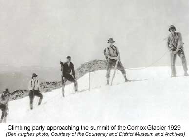
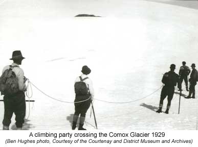
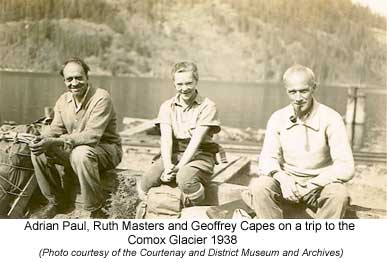
Although a number of locals expressed an interest in following Bank's and Kinney's ascent to the glacier, it wasn't until seven years later that Ben Hughes, W.A.B. (Adrian) Paul, Arthur Leighton, C. Berkeley and his daughter Alfreda, and Geoffrey Capes made the second recorded ascent of the glacier. Several times Capes and Paul had explored the country leading up to the glacier but the difficult terrain that Kinney had experienced soon became apparent to the mountaineers and they returned home with a greater respect for the mountain.
On July 26, 1929 the party left Courtenay and drove to Comox Lake, arriving at noon; however, along the way a black cat crossed in front of their car and they took this as a sign of good luck. Harry Rees met them and motored them up to the head of the lake in his launch. By 2:15 the rain had ceased and they were shouldering their packs and ready to start up the skidder roads towards First Trout (Willemar) Lake. That night they set up their camp at Third Trout (Forbush) Lake, obviously named by the ease with which trout were caught for their evening meal.
The next morning they followed compass bearings up to the Comox Gap and then up onto Mount Evans (Kookjai Mountain.) The weather was brilliant and they had an unobstructed view of the glacier slung between two peaks. On down to Tatsno Lake and then began an ascent up a long slope of mostly bare rock to the summit of a mountain they christened, on their return, "Black Cat Mountain", owing to their success. Nowadays, Blackcat Mountain is located two kilometres northwest of where it was originally placed. From the top of the mountain they descended down to a saddle and while doing so Capes broke his alpenstock. Although not absolutely necessary it did help to keep his balance while carrying a heavy pack. A short steep climb brought them up onto a gradually rising ridge which the called the "Wagon Road." They made their campsite as comfortable as possible by backing up to a rocky ledge and building a fire in front of them. They filled their packs with heather, which served as a comfortable pillow for the night, and they dined in the lap of luxury on bacon, sausages, bread, butter, jam and coffee.
At 3:30 A.M. the eastern horizon over the Coast Mountains gradually lightened into a vivid orange until the sun rose. After a light breakfast they began moving at 5:00, taking only enough food for the day. They scrambled along the "Wagon Road" and then up through the brush-covered cliffs to arrive on the top of a small mountain (Blackcat Mountain) that connected with the main mass of "The Dome." A short descent to "Two Tree Pass" (nowadays Lone Tree Pass) and then began a leisurely climb up to the edge of the glacier. Along the way they were able to examine the many flowers growing on the scree ledges: Penstemon, Phlox, Saxifrage and Indian paint brush.
 The
glacier was low angled but a crevasse could be seen ahead so they decided
to rope up. By 10:15 they were on the summit where they spent two and
a quarter hours admiring the incredible view and taking in the breath-taking
surroundings. Upon investigating the well built cairn they found nothing
in it so they wrote their names and addresses on a piece of paper and
placed it in a box which they buried in the cairn. That morning before
leaving camp, Paul, grieving for Capes' alpenstockless condition, fashioned
out of a cedar a thick and heavy substitute; however, he now commandeered
the stick and stuck it upright into the cairn and a flag made of a Quaker
Flour sack. They then returned satisfied back to their homes but a spell
had been cast upon these men and over the years the glacier continued
to lure them back to its lofty heights.
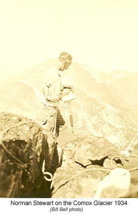
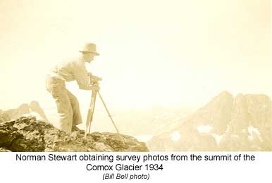
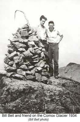
In the mid 1930's topographical surveyors and their work crews spent many weeks on the Comox Glacier and the surrounding mountains. Local men from the Comox Valley were employed as instrument men and packers to carry the supplies up to the camps: Jack Horbury, Jack Hames, George Colwell, Jock Sutherland, Dick Williams, Nick Mitchell and William (Bill) Bell. These men got to know the area well and grew to love the surrounding mountain regions, visiting it many times after their work with the surveyors was complete.
Over the years access to the glacier has become easier partly due to the roads that have been pushed in by the forestry companies, but also by a trail built by the Comox District Mountaineering Club. The trailhead is at the end of the logging road about two kilometres below Century Sam Lake on Comox Creek and climbs up onto the adjoining ridge to the south. It passes the Frog Ponds and then ascends Blackcat Mountain where it connects with the route the early pioneers took. This in itself hasn't made the trip to the Comox Glacier any safer as the dangers still exist, but it has simplified access allowing hikers to visit the glacier on two or three day weekends.
 |
 |
|
 |
 |
|
 |
 |
|
 |
 |
How to order | | About the Author || Links || Home
Contact:
Copyright ©
Lindsay Elms 2001. All Rights Reserved.
URL: http://www.beyondnootka.com
http://www.lindsayelms.ca