Island Stories:
![]() Danzig
Mine
Danzig
Mine
![]() Zeballos
Iron Mine
Zeballos
Iron Mine
![]() Conuma
Peak 1910
Conuma
Peak 1910
Alexandra Peak
Argus Mountain
Bate/Alava Sanctuary
Beaufort Range
Big Interior Mtn
Big Interior Mtn 1913
Part 1
Part 2
Bolton Expedition 1896
Cliffe Glacier
Clinton Wood
Comox Glacier
Comox Glacier 1922
Comox Glacier 1925
Comstock Mtn
Conuma Peak
Copper King Mine
Crown Mtn
Elkhorn 1912
Elkhorn 1949
Elkhorn 1968
Eugene Croteau
Golden Bullets
Golden Hinde 1913/14
Golden Hinde 1937
Golden Hinde 1983
Harry Winstone Tragedy
Jack Mitchell
Jim Mitchell Tragedy
John Buttle
Judges Route
Koksilah's Silver Mine
Landslide Lake
Mackenzie Range
Malaspina Peak
Mariner Mtn
Marjories Load
Matchlee Mountain
Mount McQuillan
Mt. Albert Edward
Mt. Albert Edward 1927
Mt. Albert Edward 1938
Mt. Becher
Mt. Benson 1913
Mt. Benson
Mt. Doogie Dowler
Mt. Colonel Foster
Mt. Hayes/Thistle Claim
Mt. Maxwell
Mt. Sicker
Mt. Tzouhalem
Mt. Whymper
Muqin/Brooks Peninsula
Nine Peaks
Queneesh
Ralph Rosseau 1947
Rosseau Chalet
Ralph Rosseau Tragedy
Rambler Peak
Red Pillar
Rex Gibson Tragedy
Sid's Cabin
Steamboat Mtn
Strathcona Park 1980's
The Misthorns
The Unwild Side
Victoria Peak
Waterloo Mountain 1865
Wheaton Hut/Marble Meadows
William DeVoe
Woss Lake
You Creek Mine
Zeballos Peak
Other Stories:
Sierra
de los Tuxtlas
Antarctica
Cerro del Tepozteco
Citlaltepetl
Huascaran
Mt. Roraima
Nevada Alpamayo
Nevada del Tolima
Nevado de Toluca
Pico Bolivar
Popocatepetl
Uluru/Ayers Rock
Volcan Purace
Volcan San Jose
Biographies
Island 6000
Cartoons
Order the Book
Contact Me
Links

Beaufort
Range:
Locals
Remembered on the East Coast Peaks
by Lindsay Elms
On the drive up the Inland Island Highway between Qualicum Beach and Courtenay there is a range of mountains immediately to the west that are relatively unknown by most people. Even residents of Courtenay and Comox, who can see this range of mountains from their homes, have little idea what it's called or could name any of the mountains in this group. It is not through ignorance but rather the lack of information available about this area. The range, known as the Beaufort Range, holds a significant meaning for residents of both the Alberni and Comox Valley as its peaks honour many local residents. These mountains stretch from Horne Lake in the south to Comox Lake in the north.
 Before
the Europeans, the First Nations People had a name for this mountain range:
Yuts-whol-aht. Translated, it means 'walking through the face of the mountains,'
which refers to the old trading trail that use to link Port Alberni to
Comox long before the logging roads were pushed through. Today the Beaufort
Range pays respect to the famous Royal Navy hydrographer Sir Francis Beaufort.
It was Captain George Richards, who was undertaking the survey of Vancouver
Island's coast in the late 1850's, who named the range as well as many
other island features. Born in 1820, Richards had a distinguished career
after joining the navy in 1837. He was promoted to Captain in 1854 and
from 1857-59 he was in charge of the HMS Plumper and from 1860-63
the HMS Hecate. In 1864 he was appointed Hydrographer and held
that position till 1874 when he retired. Richards was Knighted in 1877,
received the KCB in 1881 and became an Admiral and a Fellow of the Royal
Society in 1884. Admiral Sir George Henry Richards KCB FRS died in 1900.
Before
the Europeans, the First Nations People had a name for this mountain range:
Yuts-whol-aht. Translated, it means 'walking through the face of the mountains,'
which refers to the old trading trail that use to link Port Alberni to
Comox long before the logging roads were pushed through. Today the Beaufort
Range pays respect to the famous Royal Navy hydrographer Sir Francis Beaufort.
It was Captain George Richards, who was undertaking the survey of Vancouver
Island's coast in the late 1850's, who named the range as well as many
other island features. Born in 1820, Richards had a distinguished career
after joining the navy in 1837. He was promoted to Captain in 1854 and
from 1857-59 he was in charge of the HMS Plumper and from 1860-63
the HMS Hecate. In 1864 he was appointed Hydrographer and held
that position till 1874 when he retired. Richards was Knighted in 1877,
received the KCB in 1881 and became an Admiral and a Fellow of the Royal
Society in 1884. Admiral Sir George Henry Richards KCB FRS died in 1900.
The highest mountain in the Beaufort Range is Mount Joan (1,557m) and is located towards the southern end of the range. It is named after Joan Moorehead, a resident of the industrial town of Port Alberni. Just over five kilometres to the south of Mount Joan is Mount Hal (1,489m) also named after a member of the Moorehead family: Hal Moorehead was Joan's brother. The southern most peak on the Beaufort range is Mount Irwin (1,400m.)
As the mountains extend north from Mount Joan there is the descriptive The Squarehead (1,509m) and Mount Curran (1,478m), named after Fred and Mary Curran of Mud Bay south of the Denman Island Ferry Terminal. The Curran's owned a farm on Rosewall Creek and in 1943 assisted the surveyors offering them a place to stay and helping out because of their familiarity with the area. Fred was a Captain with the Pacific Coast Militia Rangers, an outfit formed during the Second World War that was the equivalent of a Home Guard. Then there is Mount Apps (1,537m) named after George Apps, a former teacher and school principle of Cumberland Elementary School. George had little experience in the outdoors; however, his son Don is a mountaineer and avid hiker with the Comox District Mountaineering Club and has probably spent more time in these mountains then anybody else. Many of his days are spent hiking in the Beauforts or working on the access trails.
 Further
to the north is Mount Henry Spencer (1,482m), named after a well-known
Comox Valley resident and politician who helped establish the health care
system in Canada in the 1920's. On the summit of this mountain there is
a rock cairn with a brass plaque commemorating the Spencer family. Next
is Mount Stubbs (1,479m), which honours a Courtenay school principle,
philosopher and writer, William G. Stubbs. Tsable Mountain (1,490m) derives
its name from the river that flows from nearby and then there is Mount
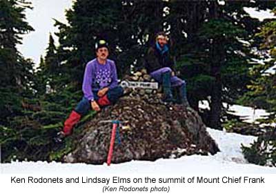
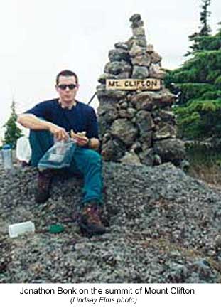
Chief Frank (1,470m) and Mount Clifton (1,440m.) These two latter mountains
are named after prominent local First Nations People: Chief Frank and
Robert Clifton. Both men contributed in many ways to the history and the
preservation of native culture in the Comox Valley.
Further
to the north is Mount Henry Spencer (1,482m), named after a well-known
Comox Valley resident and politician who helped establish the health care
system in Canada in the 1920's. On the summit of this mountain there is
a rock cairn with a brass plaque commemorating the Spencer family. Next
is Mount Stubbs (1,479m), which honours a Courtenay school principle,
philosopher and writer, William G. Stubbs. Tsable Mountain (1,490m) derives
its name from the river that flows from nearby and then there is Mount
Chief Frank (1,470m) and Mount Clifton (1,440m.) These two latter mountains
are named after prominent local First Nations People: Chief Frank and
Robert Clifton. Both men contributed in many ways to the history and the
preservation of native culture in the Comox Valley.
Courtenay's Ruth Masters is responsible for the naming of most of the peaks on the Beaufort Range as well as many of the small lakes on Forbidden Plateau. Born and raised in the Comox valley, Ruth Masters is a wealth of knowledge about the early pioneers, and since her early childhood she has been involved with the Comox District Mountaineering Club. She has skied, hiked and paddled with such people as the late Sid Williams, Geoffrey Capes and Ben Hughes to name just a few. Masters believes in honouring local residents of the Comox Valley, people who have over the years made "outstanding contributions" to the history of the area. After visiting the summits Masters always leaves a little reminder of the people they honour. Most have a piece of cedar with the name of the peak carved into it, which is then placed in a rock cairn so that as hikers pass by they have a visual reminder of the people.
 The
high-level traverse or 'Haute Route' of the Beaufort Range, starting at
Mount Clifton and culminating at Mount Joan, is a multi-day hiking trip
with outstanding views. To the east are the islands in the Straits of
Georgia and the mainland of British Columbia, and to the west are the
Cliffe Glacier
and Comox Glacier
and the myriad of lakes that shimmer in the summer sun down to Port Alberni.
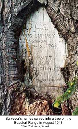
Along the way reminders can be found of the other pioneers. Surveyors
in the 1930's, '40's and '50's, who were mapping Vancouver Island, carved
their names into the trees along the way and at certain places can still
be found.
The
high-level traverse or 'Haute Route' of the Beaufort Range, starting at
Mount Clifton and culminating at Mount Joan, is a multi-day hiking trip
with outstanding views. To the east are the islands in the Straits of
Georgia and the mainland of British Columbia, and to the west are the
Cliffe Glacier
and Comox Glacier
and the myriad of lakes that shimmer in the summer sun down to Port Alberni.
Along the way reminders can be found of the other pioneers. Surveyors
in the 1930's, '40's and '50's, who were mapping Vancouver Island, carved
their names into the trees along the way and at certain places can still
be found.
All the peaks on the Beaufort Range are accessible as day trips in both summer and winter; however, access can be restricted by logging activity as most of the roads are privately owned by logging companies. Many of the mountains can be reached via trails off the Alberni/Comox Logging road. The trailheads are usually unmarked and the best way to get access and trail information is to contact the Comox District Mountaineering Club who regularly organize hiking trips into the Beaufort Range.
So next time you're looking up at the Beaufort Range remember that some of the early pioneers of the Comox and Alberni Valley are honoured up there. Man made features named after locals can be torn down but a mountain is there forever.
How to order | | About the Author || Links || Home
Contact:
Copyright ©
Lindsay Elms 2001. All Rights Reserved.
URL: http://www.beyondnootka.com
http://www.lindsayelms.ca