Island Stories:
![]() Danzig
Mine
Danzig
Mine
![]() Zeballos
Iron Mine
Zeballos
Iron Mine
![]() Conuma
Peak 1910
Conuma
Peak 1910
Alexandra Peak
Argus Mountain
Bate/Alava Sanctuary
Beaufort Range
Big Interior Mtn
Big Interior Mtn 1913
Part 1
Part 2
Bolton Expedition 1896
Cliffe Glacier
Clinton Wood
Comox Glacier
Comox Glacier 1922
Comox Glacier 1925
Comstock Mtn
Conuma Peak
Copper King Mine
Crown Mtn
Elkhorn 1912
Elkhorn 1949
Elkhorn 1968
Eugene Croteau
Golden Bullets
Golden Hinde 1913/14
Golden Hinde 1937
Golden Hinde 1983
Harry Winstone Tragedy
Jack Mitchell
Jim Mitchell Tragedy
John Buttle
Judges Route
Koksilah's Silver Mine
Landslide Lake
Mackenzie Range
Malaspina Peak
Mariner Mtn
Marjories Load
Matchlee Mountain
Mount McQuillan
Mt. Albert Edward
Mt. Albert Edward 1927
Mt. Albert Edward 1938
Mt. Becher
Mt. Benson 1913
Mt. Benson
Mt. Doogie Dowler
Mt. Colonel Foster
Mt. Hayes/Thistle Claim
Mt. Maxwell
Mt. Sicker
Mt. Tzouhalem
Mt. Whymper
Muqin/Brooks Peninsula
Nine Peaks
Queneesh
Ralph Rosseau 1947
Rosseau Chalet
Ralph Rosseau Tragedy
Rambler Peak
Red Pillar
Rex Gibson Tragedy
Sid's Cabin
Steamboat Mtn
Strathcona Park 1980's
The Misthorns
The Unwild Side
Victoria Peak
Waterloo Mountain 1865
Wheaton Hut/Marble Meadows
William DeVoe
Woss Lake
You Creek Mine
Zeballos Peak
Other Stories:
Sierra
de los Tuxtlas
Antarctica
Cerro del Tepozteco
Citlaltepetl
Huascaran
Mt. Roraima
Nevada Alpamayo
Nevada del Tolima
Nevado de Toluca
Pico Bolivar
Popocatepetl
Uluru/Ayers Rock
Volcan Purace
Volcan San Jose
Biographies
Island 6000
Cartoons
Order the Book
Contact Me
Links

Steamboat
Mountain:
Another
'Hit' on the 'Thrash Parade'
by Lindsay Elms
The mountains on either side of Highway 4 between Port Alberni and Long Beach on the West Coast have long been considered rugged. The approach through the lush, temperate rainforest can be a grueling undertaking when there is no trail to follow and is enough to turn many ardent mountaineers off. Many of these peaks are rarely visited and there are some summits that have only in the last few years seen first ascents: Mount Hall (1,440+m) in 2002, and Toquart Peak (1,280+m) and Sawtooth Peak (1,440+m) in 2003.
The Maitland Range lies on the west side of Highway 4 and it stretches (south to north) from Mount Maitland (1,200+m), Hidden Peak (1,465m) and its myriad of rocky towers, Steamboat Mountain (1,484m) and The Limestone Twins, and Pogo Peak, formerly Tit Mountain (1,485m.) The surveyors Robert McCaw and George Jackson possibly climbed Mount Maitland in 1941 along with Pogo Mountain, Hidden Peak by a party from Nanaimo's Island Mountain Ramblers in 1975, and Steamboat Mountain by members of the Vancouver Island section of the Alpine Club of Canada. However, the slightly lower summit half a kilometre to the south (1,395m) was climbed and a survey bolt put in place in 1941 by the surveyors as was the northeast summit (1,349m). It is highly possibly that they scrambled the last twenty minutes to the main summit but there is no record of that ascent.
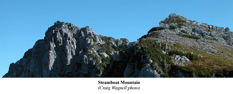 |
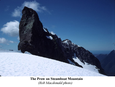
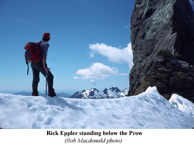
In the 1988 Fall Bushwhacker of the Vancouver Island section of the Alpine Club of Canada Rob Macdonald wrote a story entitled: Steamboat (4,800'); Another Maitland Range Classic? This was the second attempt by Rob Macdonald and Rick Eppler on this peak. Although the mountain had no official name, they had started calling this peak Steamboat Mountain due to the fact that it comprised of two summits which appeared to be of equal height, and resembled a steamboat when viewed from neighbouring peaks, with the prominent angled prow of old-style steam ships.
Macdonald begins by saying:
Rick Eppler keeps doing it to me. I remember an attempt we made on this peak with James Budac (March 1985). Rick said it would be a good time to go because the snow would cover the bush - he was right, we wallowed up to the waist in snow and I don't recall my feet getting caught up in a bush anywhere: there came a point when I would dearly have loved a bush, even Devil's Club to stand on in bare feet.
They got to a highpoint on the northeast shoulder at dark and decided they weren't prepared for a night out. After hauling their wary bodies back down they arrived at the vehicle at 1 A.M.. Macdonald said he believes this trip to be his 'personal best' thrash.
On July 17, 1988, Macdonald and Eppler settled on a return trip to Steamboat Mountain: "I think Rick said that the snow wouldn't be too bad - perhaps he meant that it would be covered by the bush." At the end of a logging road between Steamboat and Pogo Peak, Macdonald and Eppler took to the slash to get into passable woods. Well, it wasn't long before Macdonald said the bush started to show its teeth.
At one point, as we clambered over loose rocks defended by Salmonberry and Devil's Club I found myself thinking 'well, it could be worse - we could step in a wasp's nest …' that's when we stepped in a wasp nest - I still have the marks. Anyway, a little farther, the bush really put on its show. Desperation, and not necessity, is the mother of invention; I suggested we should try the creek-bed.
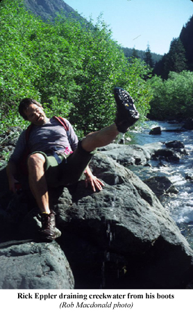 Much
to Macdonald's delight the creek-bed went like a charm. At first they
hopped from boulder to boulder and were able to keep dry feet, however,
they soon came to a point where there were small waterfalls and the bush
literally grew over the creek. It was time to get wet feet. They continued
up the creek-bed and Macdonald said " … I've never been so delighted
to gaze up at those awful, fetid, hot, bush-covered, wasp-ridden avalanche
slopes which swept down into the creek - we weren't on them and we weren't
going to be on them." They followed this creek-bed for another hour,
finally stepping directly onto the snow at the bottom of the northwest
gully that took them to the summit ridge.
Much
to Macdonald's delight the creek-bed went like a charm. At first they
hopped from boulder to boulder and were able to keep dry feet, however,
they soon came to a point where there were small waterfalls and the bush
literally grew over the creek. It was time to get wet feet. They continued
up the creek-bed and Macdonald said " … I've never been so delighted
to gaze up at those awful, fetid, hot, bush-covered, wasp-ridden avalanche
slopes which swept down into the creek - we weren't on them and we weren't
going to be on them." They followed this creek-bed for another hour,
finally stepping directly onto the snow at the bottom of the northwest
gully that took them to the summit ridge.
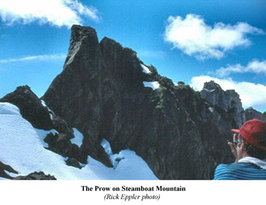
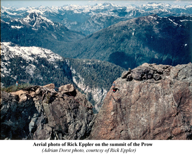
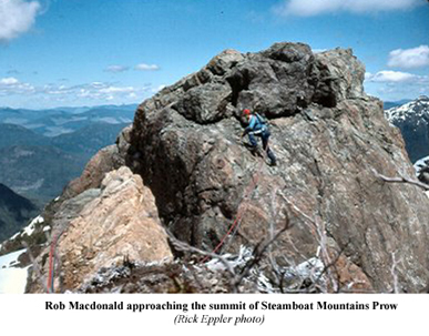
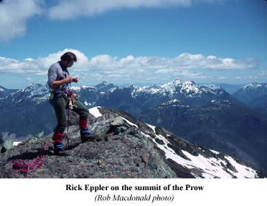
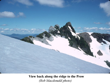
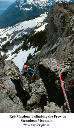
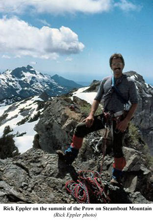
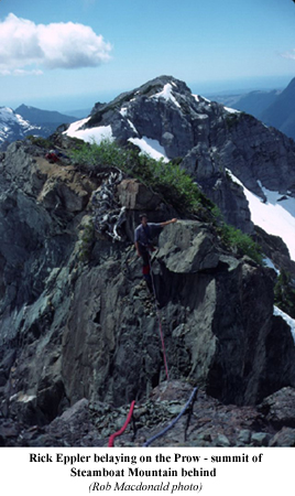
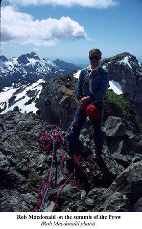
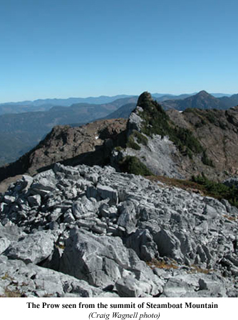
The two traversed under a spectacular two hundred foot prow and went directly to the easy main limestone summit. Visibility was unlimited and the views were amazing. From the main summit they dropped down the way they came and followed the ridge to climb the 'Prow' from the southwest. The last bit involved a loose narrow gap and a not-to-difficult face climb that Macdonald led while Eppler belayed to get to the summit block. At 2:30 P.M. they were sitting on the top when they saw a plane veering towards them. The plane circled and flew off. Later when they contacted Tofino Air they found out that it was the photographer Adrian Dorst who was flying around to get photos for his book Clayoquot: The Wild Side and he had taken some photos of them of the top proving they were there.
The trip back down to the vehicle went smoothly: "What could have been another 'Hit' on the 'Thrash Parade' turned into a remarkably fine trip." Upon returning to Victoria, Eppler submitted the name 'Steamboat Mountain' to the B.C. Geographic Names Department for official recognition. Macdonald wrote: "Rick says the name Steamboat has been officially accepted; don't let him kid you that this has anything to do with the appearance of the mountain - it is because at the end of the trip, you feel like you've been through a paddle-wheel."
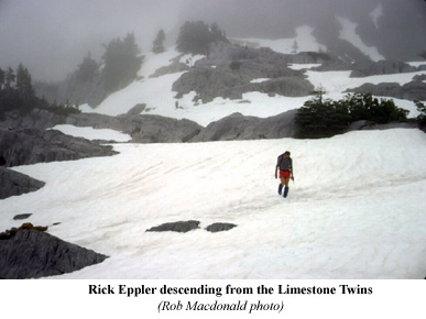
 This
wasn't the last trip into Steamboat Mountain for Macdonald and Eppler.
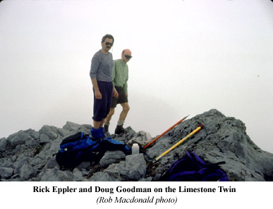
Five years later in early June 1993 they returned with five others to
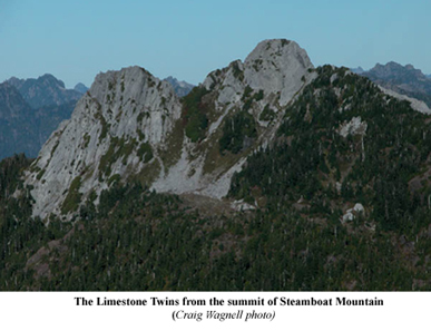
climb The Limestone Twins on the northwestern side of the mountain. This
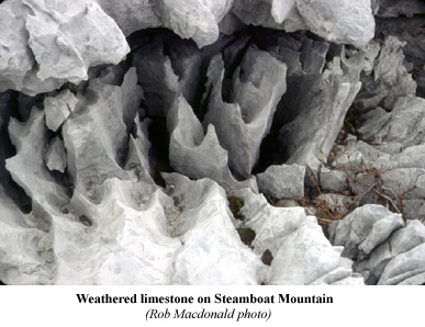
part of the mountain is known as the Clayoquot Plateau and is characterized
by areas of massive limestone intrusions belonging to the Quatsino Formation,
laid down during the Upper Triassic period. The limestone has weathered
to form the sharp summits of The Limestone Twins and surrounding grey
ridges of Steamboat Mountain.
This
wasn't the last trip into Steamboat Mountain for Macdonald and Eppler.
Five years later in early June 1993 they returned with five others to
climb The Limestone Twins on the northwestern side of the mountain. This
part of the mountain is known as the Clayoquot Plateau and is characterized
by areas of massive limestone intrusions belonging to the Quatsino Formation,
laid down during the Upper Triassic period. The limestone has weathered
to form the sharp summits of The Limestone Twins and surrounding grey
ridges of Steamboat Mountain.
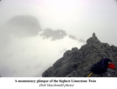
Spelunkers began venturing onto this plateau in the early 1990's searching for caves and cut a nice trail that led to a camp in the sub alpine on the northern end of the Twins massif, right beside an idyllic little alpine tarn. It was this trail that the seven ventured up on their quest to visit these unclimbed summits.
At the end of the logging road between Steamboat and Pogo Mountain they set up camp for the night. After swatting black flies and no-see-ums all night, they were away at first light with fog and clouds swirling around the ridges above. Several false leads were required taken they found the well-worn cavers trail. Conditions never improved and as they got higher spirits dropped as the drizzle increased. Of the seven who began it ended up becoming a party of three (Eppler, Macdonald and Doug Goodman) as visibility dropped, at times down to thirty metres. They continued moving up a shallow break in the wall filled by a snow slope angling up to who knew where. Staring mystified into the mist they had no idea where the high point was so they just kept moving south along the ridge until confronted by a substantial drop. "Could this be one of the elusive Limestone Twins we were seeking?"
They tried recalling aerial photographs of the mountain and seemed to remember a substantial bump between their perceived position and where they wanted to be so of they headed off to find what they could not see. The bump proved to be an entertaining scramble and soon they were sitting on top of another with an even steeper, nastier looking drop below their feet. This was their last kick at the summit as the weather was not good, it was getting on in the day and they were postulating that they should think about catching up with the others. Just then there was a little break in the mist. Eppler writes:
A couple of quick knowing glances and without a word we were off down a grotty, steep, slimy, loose class 3 gully into the gap, chasing that almighty elusive glimpse. With equal zeal we kicked up the steep snow to the base of the first tower. Traversing out onto the North Face away from the imposing East Face proved to be the key to a couple of easy class 3-4 grooves to the summit.
Hah! Who says blind ignorance does pay off? A faint view of the other Twin showed it to be lower, with an intricate-looking and time gobbling gap to get there, so leaving nothing but our names in a film canister and a pile of rocks, we disappeared into the mist from where we had come.
 Knowing
the others would be feeling miserable and dejected, while they were leaping
amongst the clouds, elated at having summitted, the chase was on. There
must have been something to that as although the others had an hour and
a half start on them, they caught up with them at the edge of the forest
two hundred metres from the vehicles.
Knowing
the others would be feeling miserable and dejected, while they were leaping
amongst the clouds, elated at having summitted, the chase was on. There
must have been something to that as although the others had an hour and
a half start on them, they caught up with them at the edge of the forest
two hundred metres from the vehicles.
Between 1995 and 1998, and 2000 to 2001 another caver/climber was regularly visiting Steamboat Mountain. Craig (Quagger) Wagnell from Port Alberni and was mainly interested in the caves interspersed throughout the limestone intrusions. He accessed the mountain's caves via several different routes but established a new route directly up from the highway that reaches the alpine in a matter of hours. This rough trail has become the standard route for him and a few others over the last couple years and with more feet trampling a worn path it will see more people visiting the limestone formations and caves, as well as the various summits.
Another access
route was established up Steamboat Mountain by Sandy Briggs and Don Berryman
in early September 1998. Briggs and Berryman were members of the Vancouver
Island section of the Alpine Club of Canada and were familiar with 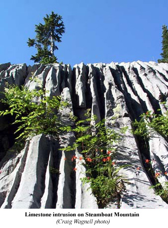 the
rugged terrain in this area having climbed many of the surrounding peaks.
On the first day they drove from Victoria to the end of the logging road
between Steamboat and Pogo Mountain and hid a bicycle in the woods near
the start of the Caver's Trail into the Clayoquot Plateau. They then drove
around to the Kenquot Main logging road between Hidden Peak and Steamboat
Mountain. After hiking up the logging road almost to the saddle they veered
right and then deeked off through the slash and followed up beside a creek
to a col on the South Ridge. They then basically followed the ridge all
the way to the summit. No technical difficulties or major bluffs were
encountered and the bush was relatively user friendly so very little serious
bushwhacking was involved.
the
rugged terrain in this area having climbed many of the surrounding peaks.
On the first day they drove from Victoria to the end of the logging road
between Steamboat and Pogo Mountain and hid a bicycle in the woods near
the start of the Caver's Trail into the Clayoquot Plateau. They then drove
around to the Kenquot Main logging road between Hidden Peak and Steamboat
Mountain. After hiking up the logging road almost to the saddle they veered
right and then deeked off through the slash and followed up beside a creek
to a col on the South Ridge. They then basically followed the ridge all
the way to the summit. No technical difficulties or major bluffs were
encountered and the bush was relatively user friendly so very little serious
bushwhacking was involved.
From the summit they descended to the lakes on the west side and bivvied out for the night. The next day they went across to the Clayoquot Plateau and found the Caver's Trail back down to their hidden bicycle. Don then just had to ride the bike back down the logging road, out onto the highway and back onto the Kenquot Main where he had left the car. This was more than likely the first traverse of the mountain from south to north.
Steamboat
Mountain, like many of the other surrounding peaks, is rarely visited
although the spectacular limestone features make it a worthwhile trip.
It is also possible that there is unique flora growing on the limestone
plateaus as well as fauna that might reside in the caves. It will take
a keen eye and someone with a bit of knowledge to identify any new species
but no one will be disappointed with the excursion, and more-than-likely,
will want to make a return trip to this exceptional landscape.
 |
 |
 |
 |
 |
 |
 |
 |
 |
 |
 |
 |
 |
 |
 |
How to order | | About the Author || Links || Home
Contact:
Copyright ©
Lindsay Elms 2001. All Rights Reserved.
URL: http://www.beyondnootka.com
http://www.lindsayelms.ca