Island Stories:
![]() Danzig
Mine
Danzig
Mine
![]() Zeballos
Iron Mine
Zeballos
Iron Mine
![]() Conuma
Peak 1910
Conuma
Peak 1910
Alexandra Peak
Argus Mountain
Bate/Alava Sanctuary
Beaufort Range
Big Interior Mtn
Big Interior Mtn 1913
Part 1
Part 2
Bolton Expedition 1896
Cliffe Glacier
Clinton Wood
Comox Glacier
Comox Glacier 1922
Comox Glacier 1925
Comstock Mtn
Conuma Peak
Copper King Mine
Crown Mtn
Elkhorn 1912
Elkhorn 1949
Elkhorn 1968
Eugene Croteau
Golden Bullets
Golden Hinde 1913/14
Golden Hinde 1937
Golden Hinde 1983
Harry Winstone Tragedy
Jack Mitchell
Jim Mitchell Tragedy
John Buttle
Judges Route
Koksilah's Silver Mine
Landslide Lake
Mackenzie Range
Malaspina Peak
Mariner Mtn
Marjories Load
Matchlee Mountain
Mount McQuillan
Mt. Albert Edward
Mt. Albert Edward 1927
Mt. Albert Edward 1938
Mt. Becher
Mt. Benson 1913
Mt. Benson
Mt. Doogie Dowler
Mt. Colonel Foster
Mt. Hayes/Thistle Claim
Mt. Maxwell
Mt. Sicker
Mt. Tzouhalem
Mt. Whymper
Muqin/Brooks Peninsula
Nine Peaks
Queneesh
Ralph Rosseau 1947
Rosseau Chalet
Ralph Rosseau Tragedy
Rambler Peak
Red Pillar
Rex Gibson Tragedy
Sid's Cabin
Steamboat Mtn
Strathcona Park 1980's
The Misthorns
The Unwild Side
Victoria Peak
Waterloo Mountain 1865
Wheaton Hut/Marble Meadows
William DeVoe
Woss Lake
You Creek Mine
Zeballos Peak
Other Stories:
Sierra
de los Tuxtlas
Antarctica
Cerro del Tepozteco
Citlaltepetl
Huascaran
Mt. Roraima
Nevada Alpamayo
Nevada del Tolima
Nevado de Toluca
Pico Bolivar
Popocatepetl
Uluru/Ayers Rock
Volcan Purace
Volcan San Jose
Biographies
Island 6000
Cartoons
Order the Book
Contact Me
Links

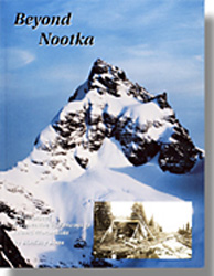 BEYOND
NOOTKA:
BEYOND
NOOTKA: A
Historical Perspective
of
Vancouver Island Mountains
Misthorn Press ISBN 0968015905
by Lindsay Elms
Introduction by Sandy Briggs
About
the Book:
[
Site updated:
February 5, 2017 12:46 PM
]
The first two chapters cover the periods 1579 - 1892 and 1894 - 1910. It begins with the possible sighting of Vancouver Island by the famous British navigator Sir Francis Drake to contact with the First Nations People by the Spaniard Captain Juan Perez off Estevan Point and the landing by Captain James Cook at Nootka Sound to the purchasing of land by Captain John Meares from Chief Maquinna. Due to land claims on the west coast by both Spain and Britain, a war between the two almost broke out but was quelled by the signing of the Nootka Convention. Eventually the British government granted Vancouver Island to the Hudson's Bay Company on the understanding that they establish settlements on the island within five years. Thus began the age of exploration on Vancouver Island.
Explorers
such as Captain Hamilton Moffat, Adam Horne, Joseph Pemberton,
Dr. Robert Brown, John Buttle, Joe Drinkwater and
Rev. William Bolton traversed the island in various places, some
covering old native trade routes while others endured the challenges of
exploring completely uncharted regions. In one of the stories it is suggested
that John Buttle, the commander of the 1865 Vancouver Island
Exploring Expedition and thought to be the first European to see Buttle
Lake, the crown of lakes on the island, was in fact looking at Great
Central Lake. Other stories deal with the meetings between the explorers
and Indians. In 1856 Adam 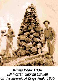 Horne's
party paddled
canoes to the mouth of the Qualicum River and there hid while a
large party of Haida Indians approached the river. After waiting
several hours the Haida finally came back into view, renting the air with
shouts and yells and holding human heads by the hair. This was one of
the worst massacres on the west coast.
Horne's
party paddled
canoes to the mouth of the Qualicum River and there hid while a
large party of Haida Indians approached the river. After waiting
several hours the Haida finally came back into view, renting the air with
shouts and yells and holding human heads by the hair. This was one of
the worst massacres on the west coast.
Of course not all the explorers had to deal with such atrocities. Many hired the native people as guides and without their aid would not have been as successful as they were. In some cases it was the hardship of the weather and environment that they had to deal with. The hardships endured can only be judged by the names they gave to some of the rivers: Misery Creek, Hungry Creek, Famine River and Starvation Creek.
It was the reports from the early explorers which led the British Columbia Provincial Government to propose that a park be established in the interior of the island. In 1910 an expedition was organized to visit the area around Buttle Lake and during the course of the expedition Crown Mountain was climbed. On this expedition twenty year old Myra Ellison was the first to reach the summit. One year later Strathcona Park, British Columbia's first provincial park, was established.
The next six chapters cover six of the most significant mountains on Vancouver
Island. The Golden Hinde is the highest at 2200m, named after Sir
Francis Drake's flagship, a mountain whose early climbing history
was only revealed through an interview with a climbing/surveying pioneer
as late as 1990. Elkhorn is the second highest at 2166m named by
the Alpine Club of Canada expedition who in 1912 were the first
to scale the mountain. Originally called the Strathcona Matterhorn
because of its resemblance to the famous Matterhorn mountain in Switzerland,
it became known as Elkhorn because it towered above the Elk valley. Big
Interior Mountain, whose history is shrouded by mining dating back
to 1899. Big Interior has both gold and copper interspersed throughout
its granite and limestone folds. The mine sites near the summit were visited
by South African and English gentry in 1913: The Earl of Denbigh,
Lady Marjorie Feilding, Major Frank Johnson and Sir James Sivewright.
Lower down on the mountain is the beautiful Della Lake, source
of Della Falls, the highest waterfall in Canada.
The most spectacular mountain is Mount Colonel Foster, a mountain
whose 1000m high East Face offers some of the hardest climbing on Vancouver
Island. A mountain which has seen some of the greatest climbers test their
skills in both summer and winter: Doug Scott, Greg Child,
Rob Wood, Joe Bajan and Mike Walsh. Mount Arrowsmith
which for many years was thought to be the highest mountain on the island.
It's lofty summit stands out above the towns of Nanaimo and Port Alberni,
and can be seen from Vancouver. At the turn of the twentieth century the
famous Swiss mountaineer Edward Whymper (of the Matterhorn fame)
was reported to have climbed to the summit of Arrowsmith. Finally toward
the north end of the island is Rugged Mountain in the Haihte
Range. Although its climbing history 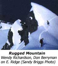 is
relatively recent it had a story of a mystery summit box and bottle of
champagne that piqued the curiosity of climber Sandy Briggs. The
mountains of the Haihte Range were scoured until it was finally found
but the question remains why it was not found where it was said to be.
is
relatively recent it had a story of a mystery summit box and bottle of
champagne that piqued the curiosity of climber Sandy Briggs. The
mountains of the Haihte Range were scoured until it was finally found
but the question remains why it was not found where it was said to be.
The last chapter covers the topographical surveyors who surveyed the mountain regions of Vancouver Island between 1913 - 1941. Their achievements have been little acknowledged but their detailed maps that they spent years compiling information for have become objects that we take for granted. Little do we realize the effort that went into these maps, maps that we are wise to always take into the mountains.
The stories
in BEYOND NOOTKA are not all full of "pitons" and "belays."
The major themes of climbing on Vancouver Island have been covered - from
its struggles and disappointments to its sense of camaraderie, triumph
and humour. From the long warm summer climbs to the harrowing accounts
of trying to achieve first winter ascents, BEYOND NOOTKA brings
to life the true emotional feel of a successful climb. BEYOND NOOTKA
has a complete bibliography, footnotes for those interested in further
research, copies of some of the old explorers' maps dating back to 1792
and a lots of historical black and white photographs and colour photographs
of modern climbers in action on the mountains of Vancouver Island.
How to order | | About the Author || Links || Home
Contact:
Copyright ©
Lindsay Elms 2001. All Rights Reserved.
URL: http://www.beyondnootka.com
http://www.lindsayelms.ca