Island Stories:
![]() Danzig
Mine
Danzig
Mine
![]() Zeballos
Iron Mine
Zeballos
Iron Mine
![]() Conuma
Peak 1910
Conuma
Peak 1910
Alexandra Peak
Argus Mountain
Bate/Alava Sanctuary
Beaufort Range
Big Interior Mtn
Big Interior Mtn 1913
Part 1
Part 2
Bolton Expedition 1896
Cliffe Glacier
Clinton Wood
Comox Glacier
Comox Glacier 1922
Comox Glacier 1925
Comstock Mtn
Conuma Peak
Copper King Mine
Crown Mtn
Elkhorn 1912
Elkhorn 1949
Elkhorn 1968
Eugene Croteau
Golden Bullets
Golden Hinde 1913/14
Golden Hinde 1937
Golden Hinde 1983
Harry Winstone Tragedy
Jack Mitchell
Jim Mitchell Tragedy
John Buttle
Judges Route
Koksilah's Silver Mine
Landslide Lake
Mackenzie Range
Malaspina Peak
Mariner Mtn
Marjories Load
Matchlee Mountain
Mount McQuillan
Mt. Albert Edward
Mt. Albert Edward 1927
Mt. Albert Edward 1938
Mt. Becher
Mt. Benson 1913
Mt. Benson
Mt. Doogie Dowler
Mt. Colonel Foster
Mt. Hayes/Thistle Claim
Mt. Maxwell
Mt. Sicker
Mt. Tzouhalem
Mt. Whymper
Muqin/Brooks Peninsula
Nine Peaks
Queneesh
Ralph Rosseau 1947
Rosseau Chalet
Ralph Rosseau Tragedy
Rambler Peak
Red Pillar
Rex Gibson Tragedy
Sid's Cabin
Steamboat Mtn
Strathcona Park 1980's
The Misthorns
The Unwild Side
Victoria Peak
Waterloo Mountain 1865
Wheaton Hut/Marble Meadows
William DeVoe
Woss Lake
You Creek Mine
Zeballos Peak
Other Stories:
Sierra
de los Tuxtlas
Antarctica
Cerro del Tepozteco
Citlaltepetl
Huascaran
Mt. Roraima
Nevada Alpamayo
Nevada del Tolima
Nevado de Toluca
Pico Bolivar
Popocatepetl
Uluru/Ayers Rock
Volcan Purace
Volcan San Jose

You
Creek Mine:
A
Gold Laced Mountain
by Lindsay Elms
Since the establishment of Strathcona Provincial Park in 1911 mining within its boundaries has been a controversial issue. Unfortunately, some of the mining claims have been crown granted which gives them certain exemptions under the Parks Act. One such group of claims that was crown granted was staked in the You Creek watershed in Strathcona's southern area.
Located on the southwest slopes of Big Interior Mountain above You Creek, one of the largest tributaries of the Bedwell River, is a group of four mining claims known as Ex, Ten, You, Eight, and called the You Group. This group was first located in 1912 during the active period on Big Interior Mountain by Ptarmigan Mines Ltd., an adjacent property owned by a syndicate of British and South African businessmen. The four claims are between 1,800 and 2,200 feet in elevation, and the gold-bearing quartz vein is in a three foot shear in granodiorite which is the predominant rock on the lower forested slopes of the mountain. This is quite different from the conspicuous thick limestone cap found on the summit of Big Interior Mountain where the copper rich Ptarmigan Mine is located.
In 1921 the You Group owner J.B. Woodworth of Vancouver, hired William M. Brewer a mining engineer to visit the claims. Brewer wrote the following description of the property:
The fissure is exposed in a narrow gulch, the effects of erosion, for a vertical height of about 500 feet above the trail, where an adit is driven along a strike of the vein in a northeasterly direction. Owing to the quantity of water flowing down the gulch no close examination could be made of the vein above the adit on the trail. The fissure, with similar filling, has been traced down the mountain side a distance of 500 feet below the trail, where it has been exposed in open-cuts.
That same year (1921) the claims became Crown Grants. In a report to the Minister of Mines in 1922 it was stated that "facilities for milling and concentrating could hardly be excelled, for the reason that Bedwell River can be developed to furnish all the water-power necessary to drive all machinery, as well as for concentrating purposes." Unfortunately, the spring of 1922 was a heavy snowfall season which hampered Woodworth's efforts. His camp cabin was also destroyed by fire about the time he was ready to build the small quartz-mill he had packed onto the property.
By 1923 the small homemade cyanide mill was installed and operational, however, no figures on its production are available but remains suggest a capacity of five to ten tons per day. In 1932, J.B. Woodworth returned with a small crew, and worked for a couple of months rebuilding the old camp, reconditioning the mill and driving an adit-drift 337' into the vein. Test runs showed that recoveries could be made by concentrating and cyaniding the ore and it was estimated that sufficient tonnage was available to make the property a profitable producer. Further samples were taken but by 1933 it was realized that the lack of transportation facilities was going to handicap the mine's production and it eventually was abandoned, left to stand as a ghost town.
In 1940 Bralorne Mines Ltd. inspected the property for John D. McLeod. McLeod had owned the property and undertaken some work between 1915 and 1919 prior to Woodworth but regained the property after Woodworth's ownership lapsed. In the conclusion from the Bralorne Mines report they wrote:
The quartz vein has been exposed by 340 feet of drifting disclosing a total of 1,470 tons of probable ore averaging 1.36 oz. per ton after allowing for 20% dilution in mining and a mill recovery of 95%.
With a capital outlay of $65,400 deemed sufficient to bring the property into production 1,790 tons of ore would be required to return this capital, judging the profit per ton as $36.50. The amount of additional ore required, 320 tons, seems well within the limits of the geological possibilities of the ground.
Assuming the present lengths of ore disclosed and the profit yielded by this ore per vertical foot of depth ($496) carried to a vertical depth of 500 feet, then the profit would be $248,000. The life of the mine on a 25 Ton per day basis required to realize this profit would be less than one year (272 days). Such a profit is exclusive of possibilities in the lateral extension of the present veins or in the discovery of parallel veins.
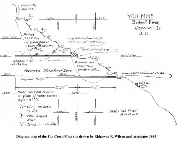
The property was again subjected to a thorough, although localized, examination by Ridgeway R. Wilson and Associates, a mining engineer firm in December 1944. The Companies conclusion was:
This crown granted group has sufficient ore of the usual narrow, high grade Vancouver Island - Zeballos type, to warrant further development of the two presently exposed shoots as well as the limited exploration of a newly discovered shoot.
It went on to recommend that combined development of at least three adjacent properties would help reduce initial and operating overhead expenditure: cost of mill, road construction, power and mine management. In their summation they said:
Obviously, almost any ore deposit on Vancouver Island may be rapidly and cheaply brought to production relative to those located in the interior of B.C. Specifically, the You Group is about five miles from a truck road. The proposed initial development would require only a pack horse trail and hand mining. It is estimated that six months work with a crew of six (one packer, one cook and four miners) would repair the camp, the trail, and ascertain the vertical continuity of the known ore shoots at an overall cost of less than $20,000 (600' to 1,000' of drifting). Hand mining would approximate $15 per foot (direct expense).
Calculations estimated one shoot could be relied upon to supply at least 2,625 tons of .88 oz. grade probable ore with a value of $80,850 [1945 prices]. Another shoot would possibly produce 2,628 tons of .86 oz. grade with a value of $79,102 (at $35/oz). Assuming, conservatively, that operating costs would not exceed $15 per ton, the operating profits would amount to $81,172 for both shoots and it was quite possible that the shoots could supply enough ore to show a profit of about $110,000 depending upon ore shoot boundaries. In January 1945 when this report from Ridgeway R. Wilson and Associates was released gold was valued at $38.50 per oz.
Unfortunately, no further work was undertaken on the property until 1960 when Tanar Gold Mines Ltd. of Vancouver stripped and test pitted the main vein to an extent of 4,100 feet on the surface. In 1961 Harvey H. Cohen, a mining engineer and Roger Verity of Tanar Gold Mines Ltd. inspected the property and wrote a favourable report but again very little work was continued with the property.
Some time in the 1980's Kilo Gold Mines Ltd. of Alberta obtained the You Group of claims and in October 1985 the President Thomas E. Kirk reported they were about to start exploration on the property. However, it appears very little was done and since that time the claims have laid idle and a luxuriant layer of moss has slowly begun to grow over everything.
Today the old cabins have disintegrated and returned to the forest floor and the old homemade cyanide mill can still be found but it too has let nature take its course. However, the adits still exists and are like doorways into the underworld of the mineral laced mountain. The quartz veins are still exposed along the walls and ceiling of the adits and the gold specks continue to sparkle when light shines upon it, allowing the viewer to dream of riches derived from the hunt for gold.
 |
How to order | | About the Author || Links || Home
Contact:
Copyright ©
Lindsay Elms 2001. All Rights Reserved.
URL: http://www.beyondnootka.com
http://www.lindsayelms.ca