Island Stories:
![]() Danzig
Mine
Danzig
Mine
![]() Zeballos
Iron Mine
Zeballos
Iron Mine
![]() Conuma
Peak 1910
Conuma
Peak 1910
Alexandra Peak
Argus Mountain
Bate/Alava Sanctuary
Beaufort Range
Big Interior Mtn
Big Interior Mtn 1913
Part 1
Part 2
Bolton Expedition 1896
Cliffe Glacier
Clinton Wood
Comox Glacier
Comox Glacier 1922
Comox Glacier 1925
Comstock Mtn
Conuma Peak
Copper King Mine
Crown Mtn
Elkhorn 1912
Elkhorn 1949
Elkhorn 1968
Eugene Croteau
Golden Bullets
Golden Hinde 1913/14
Golden Hinde 1937
Golden Hinde 1983
Harry Winstone Tragedy
Jack Mitchell
Jim Mitchell Tragedy
John Buttle
Judges Route
Koksilah's Silver Mine
Landslide Lake
Mackenzie Range
Malaspina Peak
Mariner Mtn
Marjories Load
Matchlee Mountain
Mount McQuillan
Mt. Albert Edward
Mt. Albert Edward 1927
Mt. Albert Edward 1938
Mt. Becher
Mt. Benson 1913
Mt. Benson
Mt. Doogie Dowler
Mt. Colonel Foster
Mt. Hayes/Thistle Claim
Mt. Maxwell
Mt. Sicker
Mt. Tzouhalem
Mt. Whymper
Muqin/Brooks Peninsula
Nine Peaks
Queneesh
Ralph Rosseau 1947
Rosseau Chalet
Ralph Rosseau Tragedy
Rambler Peak
Red Pillar
Rex Gibson Tragedy
Sid's Cabin
Steamboat Mtn
Strathcona Park 1980's
The Misthorns
The Unwild Side
Victoria Peak
Waterloo Mountain 1865
Wheaton Hut/Marble Meadows
William DeVoe
Woss Lake
You Creek Mine
Zeballos Peak
Other Stories:
Sierra
de los Tuxtlas
Antarctica
Cerro del Tepozteco
Citlaltepetl
Huascaran
Mt. Roraima
Nevada Alpamayo
Nevada del Tolima
Nevado de Toluca
Pico Bolivar
Popocatepetl
Uluru/Ayers Rock
Volcan Purace
Volcan San Jose
Biographies
Island 6000
Cartoons
Order the Book
Contact Me
Links

Landslide
Lake:
The 1946 Earthquake
by Lindsay Elms
 For
those who chose to reside on Vancouver Island they must live with the
constant fear of being hit by a devastating earthquake. Seismologists
don't talk about if the big one is going to hit but when and every year
that goes by without the big one shaking the island the fear increases.
Local Communities prepare themselves for the eventuality and Provincial
Emergency Programs practice procedures in the hope that they can evacuate
people quickly and efficiently from the sites where damage has resulted
and people's lives are in danger. With the growing influx of immigrants
to the island the population is constantly on the increase thus putting
more people potentially at risk. However, back in 1946, when the last
big one hit Vancouver Island its population was a mere 190,000.
For
those who chose to reside on Vancouver Island they must live with the
constant fear of being hit by a devastating earthquake. Seismologists
don't talk about if the big one is going to hit but when and every year
that goes by without the big one shaking the island the fear increases.
Local Communities prepare themselves for the eventuality and Provincial
Emergency Programs practice procedures in the hope that they can evacuate
people quickly and efficiently from the sites where damage has resulted
and people's lives are in danger. With the growing influx of immigrants
to the island the population is constantly on the increase thus putting
more people potentially at risk. However, back in 1946, when the last
big one hit Vancouver Island its population was a mere 190,000.
On Sunday morning June 23, 1946, at 10:15 A.M. Canada's largest recorded earthquake on land, measuring 7.2 in magnitude, occurred west of Courtenay with its epicenter situated in the mountainous Forbidden Plateau area. Damage was light in Courtenay because few people lived in the area, children were not in school, most buildings were small and made of wood, and there were few dams or bridges. However, in the mountainous region of Strathcona Provincial Park the earthquake struck with devastating force, fortunately no one was known to be in the vicinity.
Although there are probably quiet a few places where some form of destruction occurred there are three locations where the dramatic effects of the earthquake can be seen: Castlecrag Mountain, Cervus Creek, and in the upper Elk River valley.
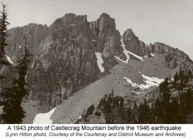
Castlecrag Mountain on the western edge of Forbidden Plateau was the closest to the epicenter and several small rock towers disintegrated as a result of the earthquake. The ensuing debris was deposited on the talus slopes below the mountain but evidence of the earthquake can only be seen by comparing photographs of the mountain before and after 1946.
 Meanwhile
in the upper reaches of the Cervus Creek a landslide occurred on the eastern
side of the valley which resulted in the debris damming the creek and
creating a lake. Although very few visit the Cervus Creek the slide path
and lake can be seen from the adjacent ridge between Elkhorn South and
Rambler Peak.
Meanwhile
in the upper reaches of the Cervus Creek a landslide occurred on the eastern
side of the valley which resulted in the debris damming the creek and
creating a lake. Although very few visit the Cervus Creek the slide path
and lake can be seen from the adjacent ridge between Elkhorn South and
Rambler Peak.
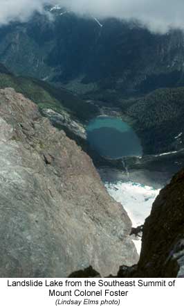
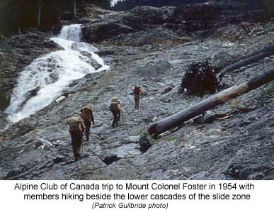
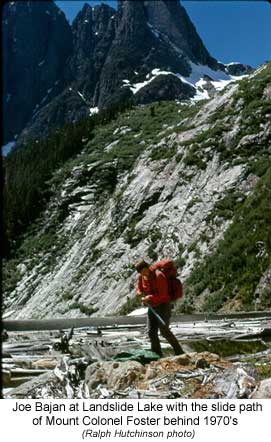
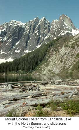
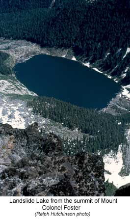
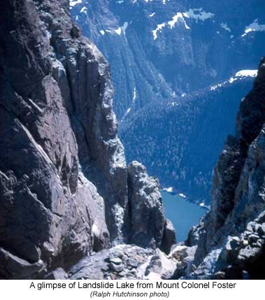
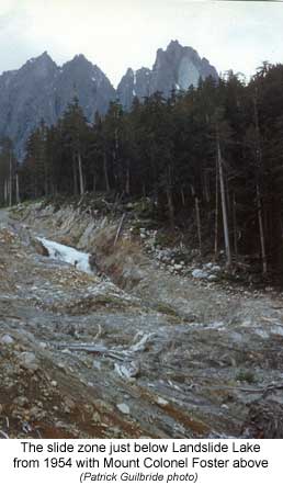
However, the most spectacular devastation was in the Elk River valley. On the North Tower of Mount Colonel Foster the earthquake jarred loose a large mass of rock leaving a huge grey scar in its place. The volume of rock was approximately 1,500,000 cubic metres and it sheared off from about 1,965m to 1,600m leaving a scar three hundred and sixty-five metres high by about one hundred metres wide. Half the volume of rock was deposited in the basin immediately below the mountain, while the rest plummeted with increasing speed down the steep slopes all the way to the lake below at eight hundred and ninety metres. Originally known as Lake Colonel Foster due to its location, it is now aptly named Landslide Lake in recognition of the geological event.
 When
the rock-fall hit the lake it created a huge displacement wave which ran
between forty-one to fifty-one metres vertically up the opposite shore
and a twenty-nine metre high wave over the lip of the lake, scouring it
clean of morainic debris and vegetation. Cedar trees over one metre in
diameter were snapped clean off, while boulders two metres in size were
swept downstream. The wave continued to devastate the upper Elk Valley
for a distance of three kilometres from the landslide, picking up more
vegetation and sediment depositing the material as alluvial flats below.
The size of the landslide-generated wave remains the largest ever recorded
in the Canadian Cordillera.
When
the rock-fall hit the lake it created a huge displacement wave which ran
between forty-one to fifty-one metres vertically up the opposite shore
and a twenty-nine metre high wave over the lip of the lake, scouring it
clean of morainic debris and vegetation. Cedar trees over one metre in
diameter were snapped clean off, while boulders two metres in size were
swept downstream. The wave continued to devastate the upper Elk Valley
for a distance of three kilometres from the landslide, picking up more
vegetation and sediment depositing the material as alluvial flats below.
The size of the landslide-generated wave remains the largest ever recorded
in the Canadian Cordillera.
Earthquakes occur all over the world; however, most occur on active faults that define the major tectonic plates of the earth. They are caused by the slow deformation of the outer, brittle portions of "tectonic plates", the earth's outermost layer of crust and upper mantle. Due to the heating and cooling of the rock below these plates, the resulting convection causes the adjacently overlying plates to move, and, under great stress, deform. The rates of plate movements range from about two to twelve centimeters per year. Sometimes, tremendous energy can build up within a single, or between neighbouring plates. If the accumulated stress exceeds the strength of the rocks making up these brittle zones, the rocks can break suddenly, releasing the stored energy as seismic waves that radiate out from the "source" in all directions and cause the ground to shake, sometimes hundreds of kilometres away
 Western
Canada is the most seismically active region in Canada. It consists of
several discrete areas of intense earthquake activity each corresponding
to a particular plate tectonic regime. The most seismic of these regions
is offshore, west of Vancouver Island. More than one hundred earthquakes
with a magnitude of 5 or greater have occurred here in the past seventy
years. Most of the seismicity occurs in areas of fractured oceanic crust,
which mark boundaries of small plates known as the Explorer and Juan de
Fuca plates. Earthquake activity is also high in the Cascadia Subduction
Zone. Here, the Juan de Fuca Plate dips below the easterly neighbouring
North American plate. Thus, both deep (dipping plate) and shallow (overriding
plate) earthquakes occur in this zone, though no earthquakes occur at
the interface of the plates.
Western
Canada is the most seismically active region in Canada. It consists of
several discrete areas of intense earthquake activity each corresponding
to a particular plate tectonic regime. The most seismic of these regions
is offshore, west of Vancouver Island. More than one hundred earthquakes
with a magnitude of 5 or greater have occurred here in the past seventy
years. Most of the seismicity occurs in areas of fractured oceanic crust,
which mark boundaries of small plates known as the Explorer and Juan de
Fuca plates. Earthquake activity is also high in the Cascadia Subduction
Zone. Here, the Juan de Fuca Plate dips below the easterly neighbouring
North American plate. Thus, both deep (dipping plate) and shallow (overriding
plate) earthquakes occur in this zone, though no earthquakes occur at
the interface of the plates.
To measure the amount of energy released during an earthquake seismologists use the term "magnitude" and is frequently described using the Richter scale. To calculate magnitude, the amplitude of waves on a seismogram is measured, correcting for the distance between the recording instrument and the earthquake epicentre. Since magnitude is representative of the earthquake itself, there is only one magnitude per earthquake. The magnitude scale is logarithmic. This means that, at the same distance, an earthquake of magnitude six produces vibrations with amplitudes ten times greater than those from a magnitude five earthquake and a hundred times greater than those from a magnitude four earthquake. In terms of energy, an earthquake of magnitude six releases about thirty times more energy than an earthquake of magnitude five and about one thousand times more energy than an earthquake of magnitude four. It is very unlikely that an earthquake of magnitude less than five could cause any damage.
So when will the next big one strike Vancouver Island? No one knows but seismologists are meticulously analyzing the continuous incoming stream of data from numerous locations and attempting to predicate and define the size of the next earthquake. As for the effect it will have in the mountains, again we don't know but going by the nature of the geology of the island, it will create displacement of some sort resulting in a physical change in the area similar to that which occurred in the Elk River valley.
 |
 |
|
 |
 |
|
How to order | | About the Author || Links || Home
Contact:
Copyright ©
Lindsay Elms 2001. All Rights Reserved.
URL: http://www.beyondnootka.com
http://www.lindsayelms.ca