Island Stories:
![]() Danzig
Mine
Danzig
Mine
![]() Zeballos
Iron Mine
Zeballos
Iron Mine
![]() Conuma
Peak 1910
Conuma
Peak 1910
Alexandra Peak
Argus Mountain
Bate/Alava Sanctuary
Beaufort Range
Big Interior Mtn
Big Interior Mtn 1913
Part 1
Part 2
Bolton Expedition 1896
Cliffe Glacier
Clinton Wood
Comox Glacier
Comox Glacier 1922
Comox Glacier 1925
Comstock Mtn
Conuma Peak
Copper King Mine
Crown Mtn
Elkhorn 1912
Elkhorn 1949
Elkhorn 1968
Eugene Croteau
Golden Bullets
Golden Hinde 1913/14
Golden Hinde 1937
Golden Hinde 1983
Harry Winstone Tragedy
Jack Mitchell
Jim Mitchell Tragedy
John Buttle
Judges Route
Koksilah's Silver Mine
Landslide Lake
Mackenzie Range
Malaspina Peak
Mariner Mtn
Marjories Load
Matchlee Mountain
Mount McQuillan
Mt. Albert Edward
Mt. Albert Edward 1927
Mt. Albert Edward 1938
Mt. Becher
Mt. Benson 1913
Mt. Benson
Mt. Doogie Dowler
Mt. Colonel Foster
Mt. Hayes/Thistle Claim
Mt. Maxwell
Mt. Sicker
Mt. Tzouhalem
Mt. Whymper
Muqin/Brooks Peninsula
Nine Peaks
Queneesh
Ralph Rosseau 1947
Rosseau Chalet
Ralph Rosseau Tragedy
Rambler Peak
Red Pillar
Rex Gibson Tragedy
Sid's Cabin
Steamboat Mtn
Strathcona Park 1980's
The Misthorns
The Unwild Side
Victoria Peak
Waterloo Mountain 1865
Wheaton Hut/Marble Meadows
William DeVoe
Woss Lake
You Creek Mine
Zeballos Peak
Other Stories:
Sierra
de los Tuxtlas
Antarctica
Cerro del Tepozteco
Citlaltepetl
Huascaran
Mt. Roraima
Nevada Alpamayo
Nevada del Tolima
Nevado de Toluca
Pico Bolivar
Popocatepetl
Uluru/Ayers Rock
Volcan Purace
Volcan San Jose

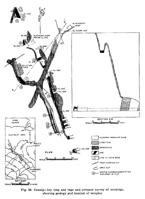
Danzig Mine on Silverado Creek: Muchalat Inlet
by Lindsay Elms
The Silverado property is located on the south shore of Muchalat Inlet, opposite the east end of Gore Island, some 12 miles east of Yuquot (Friendly Cove) and the claims lie on the west side of Silverado Creek. The lower showing is located near the mouth of the creek, on Fred Fr. claims (lot 1578), and the upper showings about 2800ft (853m) to the southeast on A.W. Fr. claim (Lot 1577) at elevations of 300 to 400ft. The showings were reportedly discovered in August 1923 and claim staking in the area was reported in 1925 and 1926. The Shannon group, owned in 1928 by A. Parke and W. Poole, of Nootka, consisted of the Little Pete claim covering the lower showing, and the Shannon and Shannon No. 1 claims covering the upper showings. By 1928 trenching and sampling had been carried out on both showings. The claims were subsequently allowed to lapse. Active prospecting for gold in this area in 1933 led to the restaking of this ground, and the discovery and staking of gold bearing veins on the other side of Silverado creek - Baltic property. The former Shannon ground was restaked as the Oregon, Danzig, Nootka, Alti, Hannah M, A.M. Fr., Fred Fr., and UP Fr. claims. The lower showing was restaked as the Fred Fr.
The claims were acquired by Danzig Mines, Inc. of Seattle, Washington. Most of the activity by the company during the period 1934 - 1938 was directed toward the Baltic property. On the Shannon ground in 1938 some 152 tons of sorted zinc ore were mined, apparently from the upper showing, and may, or may not, include 28 tons mined from a 10 foot deep trench on the lower showing. A crosscut adit (Silverado adit) was driven on the A.M. Fr. claim to cut the upper showings some 150ft below the surface outcrop. The adit intersected a faulted section of the vein and work stopped in 1938. No record has been found as to when the claims were Crown-granted as Lots 1571 - 1573, 1576 - 1579, and 1581.
No further activity was reported until September 1948 when Danzig Mines, Inc. optioned 18 Crown-granted claims to Silbak Premier Mines, Ltd. Considerable drifting on the vein from the Silverado adit opened up a mineralized shoot for a length of 23ft averaging 20% zinc over a width of 5ft. Drifting to the south on a stringer opened a short length assaying 17.8% zinc over a width of 3ft. This work failed to indicate sufficient potential and Silbak Premier gave up the option in January1949. Spud Valley Gold Mines, Ltd and Transcontinental Resources, Ltd as a joint venture optioned the property in 1951 and began further development in the Silverado adit. Work during 1951 - 1952 included some 337 feet of drifting, underground diamond drilling in 11 holes totaling 679ft, and surface diamond drilling in 12 holes totaling 2098ft. This work succeeded in delineating some 30,000 tons of medium grade mineralization.
Prospecting for gold on the Baltic property in 1933 led to the discovery of several showings. Danzig Mines, Inc. of Seattle, Washington, subsequently acquired the Baltic Nos. 1, 2, 4, 5, Gloria B, Camp Fr., Ben Hur, Warren 3, and David N claims (lots 462 - 465, 468 - 470, 474, and 475, respectively, as shown on the company claim map). Further prospecting led to the discovery of eight quartz veins on the Baltic No. 1 claim, and a "Creek vein" on the Gloria B claim at the east edge of Silverado creek. Development work by the company during the period 1934 - 1938, inclusive, was confined mainly to the No. 1 vein, near the shore of the Inlet. Open cutting and approximately 400 feet of drifting was carried out, and small quantities of ore were shipped. Development work on these showings ceased in 1938. The claims have been Crown-granted (lots 1569, 1570, 1574, 1575, 1580, 1582 - 1584). Later activity by the company, and by other companies under option agreements, was apparently confined to the Shannon property. From 1934 to 1938, inclusive, 143 tons of sorted ore were shipped from this property. From this ore 179 ounces of gold, 331 ounces of silver, and 192 pounds of copper were recovered.
From the Minister of Mines and Petroleum Resources Annual report ending December 31, 1949:
It is reported to consist of eighteen Crown-granted claims that include Lots 1568 to 1584, inclusive, and Lot 1813. Most of these claims were located between 1933 and 1937, but Lot 1813 was located in 1940.
The camp cabin, trail and road from the beach, and the two adits are shown on the key map. The Baltic adit on the beach is on Lot 1582 (Baltic No. 1 claim) and the Silverado adit on Silverado Creek is on Lot 1579 (U.P. Fraction). The Baltic adit and several surface workings prospect gold-bearing quartz veins exposed on the steep, wooded slopes immediately above the adit.
The Silverado adit, elevation 200 feet, was driven to intersect the downward extension of zinc ore exposed in surface cuts between 340 and 405 feet elevation. The surface cuts were dug and the adit driven as far as the main drift in 1938 by Danzig Mines, Inc. During this time the company hand-sorted several tons of zinc ore from the largest open-cut and conveyed it by a short aerial tramway to an orebunker about 50 feet down the hill from the adit.
Premier Gold Mines Ltd, held an option on the property between September, 1948, and January, 1949, and during the life of their option drove the main drift in the Silverado adit. No work has been done on the property since January, 1949. The Silverado adit and workings above it explore a zone of disconnected lenses of sphalerite that have partly replaced a bed of limestone 10 feet thick, strike north 20 to 30 degrees west, dip 75 degrees southwestward, along its southwestern contact with greenstone. The greenstone, a tuff or lava completely recrystallized to a hornblende hornfels, extends an unknown distance southwesterly from the showings. Northeasterly, along the crosscut, the greenstone is succeeded by another band of limestone that is not less than 80 feet thick. This limestone is cut by a northerly trending feldspar porphyry dyke, dip 70 degrees southwesterly and 15 feet wide. The zone of sphalerite lenses is traceable on the surface for 370 feet. As seen on the surface and in the drift, the lenses range in width from a few inches to 7 feet and in length from 25 to 100 feet.
Several diagonal faults cut the ore lenses. A fault at the intersection of the crosscut and the drift displaces the ore lens here, 30 feet to the left. The direction and displacement are unknown along the fault at the north end of the drift and along faults in the most northerly and southerly open-cuts magnetite in a gangue that consists principally of quartz, calcite, and light-green diopside. Much of the ore is rhythmically banded and consists of alternating layers of sphalerite and gangue one-sixteenth of an inch to an inch thick. A zone of lime-silicate minerals up to 4 feet thick occurs on either side of the ore lenses in the south drift and in the north drift extends along the west side of the ore and continues northerly to the face beyond the extent of the ore. The minerals in this zone include quartz, calcite, diopside, tan garnet, cream-coloured zoisite, and, in small amounts, scattered grains of sphalerite.
Today the
area has been extensively logged .....
 |
How to order | | About the Author || Links || Home
Contact:
Copyright ©
Lindsay Elms 2001. All Rights Reserved.
URL: http://www.beyondnootka.com
http://www.lindsayelms.ca