Island Stories:
![]() Danzig
Mine
Danzig
Mine
![]() Zeballos
Iron Mine
Zeballos
Iron Mine
![]() Conuma
Peak 1910
Conuma
Peak 1910
Alexandra Peak
Argus Mountain
Bate/Alava Sanctuary
Beaufort Range
Big Interior Mtn
Big Interior Mtn 1913
Part 1
Part 2
Bolton Expedition 1896
Cliffe Glacier
Clinton Wood
Comox Glacier
Comox Glacier 1922
Comox Glacier 1925
Comstock Mtn
Conuma Peak
Copper King Mine
Crown Mtn
Elkhorn 1912
Elkhorn 1949
Elkhorn 1968
Eugene Croteau
Golden Bullets
Golden Hinde 1913/14
Golden Hinde 1937
Golden Hinde 1983
Harry Winstone Tragedy
Jack Mitchell
Jim Mitchell Tragedy
John Buttle
Judges Route
Koksilah's Silver Mine
Landslide Lake
Mackenzie Range
Malaspina Peak
Mariner Mtn
Marjories Load
Matchlee Mountain
Mount McQuillan
Mt. Albert Edward
Mt. Albert Edward 1927
Mt. Albert Edward 1938
Mt. Becher
Mt. Benson 1913
Mt. Benson
Mt. Doogie Dowler
Mt. Colonel Foster
Mt. Hayes/Thistle Claim
Mt. Maxwell
Mt. Sicker
Mt. Tzouhalem
Mt. Whymper
Muqin/Brooks Peninsula
Nine Peaks
Queneesh
Ralph Rosseau 1947
Rosseau Chalet
Ralph Rosseau Tragedy
Rambler Peak
Red Pillar
Rex Gibson Tragedy
Sid's Cabin
Steamboat Mtn
Strathcona Park 1980's
The Misthorns
The Unwild Side
Victoria Peak
Waterloo Mountain 1865
Wheaton Hut/Marble Meadows
William DeVoe
Woss Lake
You Creek Mine
Zeballos Peak
Other Stories:
Sierra
de los Tuxtlas
Antarctica
Cerro del Tepozteco
Citlaltepetl
Huascaran
Mt. Roraima
Nevada Alpamayo
Nevada del Tolima
Nevado de Toluca
Pico Bolivar
Popocatepetl
Uluru/Ayers Rock
Volcan Purace
Volcan San Jose
Biographies
Island 6000
Cartoons
Order the Book
Contact Me
Links

William
Devoe:
And Family Remembered on
the Mountains of Strathcona Park
by
Lindsay Elms
Mountain environments anywhere in the world take their toll on the lives of those whose chosen profession takes them into the wilderness. They are not always taking undue risks but weather and mountain conditions can take the lives with unsuspecting speed: a slip or stumble on steep snow can send a climber into an uncontrollable slide or a rogue wave on a river can tip a canoe. In the early days many people learned to swim the hard way. Others unfortunately were not so lucky. One of the unlucky was William Fowler DeVoe.
DeVoe was born to Anna and William Judson DeVoe on June 13, 1885, in St. John, New Brunswick and came out to British Columbia in 1906. He worked for a short time in Trail and then went to Kaslo where he began working with Colonel William J.H. Holmes, a civil engineer and mine surveyor, on surveys around the Arrow Lakes and Skeena River. While working with Holmes, DeVoe began his studies to become a land surveyor.
 In
the spring of 1913, DeVoe passed his final examination in Victoria to
become a British Columbia Land Surveyor and continued working under the
directions of his mentor Colonel Holmes. This time Holmes was responsible
for surveying the boundary of the newly established Strathcona Provincial
Park and was one of a number of surveyors working in the park. On October
12, 1913, with the season beginning to wind down, the twenty-eight year
old DeVoe was crossing the Campbell River when he tragically drowned.
However, William DeVoe will be remembered for his meticulous work taking
topographical readings and photographs of the new park and for the mountains
he climbed and named.
In
the spring of 1913, DeVoe passed his final examination in Victoria to
become a British Columbia Land Surveyor and continued working under the
directions of his mentor Colonel Holmes. This time Holmes was responsible
for surveying the boundary of the newly established Strathcona Provincial
Park and was one of a number of surveyors working in the park. On October
12, 1913, with the season beginning to wind down, the twenty-eight year
old DeVoe was crossing the Campbell River when he tragically drowned.
However, William DeVoe will be remembered for his meticulous work taking
topographical readings and photographs of the new park and for the mountains
he climbed and named.
Throughout the summer of 1913 DeVoe climbed to various strategic viewpoints in the park where compass bearings could be taken of the surrounding country. On August 30, while working in the northwest corner of the park, DeVoe climbed to the summit of an unnamed peak. He decided to call it Mount Judson after his father William Judson DeVoe. Following is an extract from DeVoe's journal with reference to his trip:
I packed my blankets up to the summit of the Pass and at about 10 A.M. left here to climb to the Eastward arriving at the top at 11:15 A.M. The summit covers quite a large area of about the same elevation and I found a good deal of snow especially on the Northern side but also quite a lot right on the top and where exposed to the sun. I made the altitude of the summit 5495. I remained on the top until 2 P.M., took photographs around the entire circle, sketched topography of the surrounding country and built a cairn 3 ½ feet base and 6 ft high. This cairn is visible on the skyline from the valley of the (middle fork of) Salmon River, from the valley of the North Fork of the Gold River near Coldwater Creek, from the valley of Coldwater Creek, and from the valley of the East Fork of the Gold River, also from many other points except from the East where it is visible from 5000 ft or more altitude. Photographs were taken under poor conditions as the atmosphere was rather hazy for distant views. I got an excellent lookout for the surrounding country which fully repaid me for my climb. I left a record in the cairn and named the mountain "Mt Judson". I left the summit at 2 P.M. and got back down at the pass at 3.05. I do not think I will attempt a climb of this kind alone again as one takes too many chances, the first 800 or 900 feet above the pass was pretty bad on account of very heavy brush which concealed bluffs.
 Despite
his not wanting to risk another climb of that degree alone again, DeVoe
did ascend another mountain on September 11 and named it Mount Heber,
this time after his deceased older brother Heber G. DeVoe. He built a
cairn on the summit and again took many photographs. In his journal he
wrote: "Mt Heber is the meanest mountain for surveying that I have
ever had the misfortune to have anything to do with." Obviously DeVoe
was fully aware of the dangers involved with his work while in the field
and didn't want to expose himself unduly, but he had a job to do that
required a high standard of dedication.
Despite
his not wanting to risk another climb of that degree alone again, DeVoe
did ascend another mountain on September 11 and named it Mount Heber,
this time after his deceased older brother Heber G. DeVoe. He built a
cairn on the summit and again took many photographs. In his journal he
wrote: "Mt Heber is the meanest mountain for surveying that I have
ever had the misfortune to have anything to do with." Obviously DeVoe
was fully aware of the dangers involved with his work while in the field
and didn't want to expose himself unduly, but he had a job to do that
required a high standard of dedication.
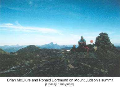
With today's knowledge and technology both Mount Judson and Heber are relatively easy mountains to climb, however, there are very few recorded ascents after DeVoe's climbs as they are not prized mountains. The following are two brief accounts of the author's climbs of Mount Judson and Heber. On September 15, 1990, Lindsay Elms, Brian McClure and Ronald Dortmund drove up the Heber River to the end of the logging road in a saddle between Mount Judson and Horseshoe Mountain. The saddle is outside of the western boundary of Strathcona Park, however, Mount Judson is located just inside the park. From the saddle the three started up the West Face of the mountain through old growth forest thick with wild huckleberries, rhododendrons and the beautiful copperbush. Quickly the terrain steepened and was interspersed with rock bluffs complicating the route finding, however, a course was found that zigzagged up the face.
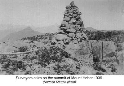
After four hundred metres they came out into the sub-alpine and from there to the summit (two hundred metres) was an easy scramble. The weather was perfect for the climb and visibility unlimited. Inside the small summit cairn was a brass survey bolt cemented into the rock by Norman Stewart, a British Columbia Land Surveyor who was working in the park in the 1930's. Five and a half kilometres to the south was Mount Heber while to the north Victoria Peak, the third highest mountain on the island, dominated the view. An hour was spent on top relaxing and enjoying the view before eventually descending back to the saddle and the car.
Three years later on July 9, 1993, Elms was back with Brian Collen to climb Mount Heber. Elms and Collen had just spent a day staring out over the mountains while climbing on the rock bluffs at Strathcona Park Lodge. After an early dinner they drove out to the Crest Mountain trailhead beside the Drum Lakes and shouldered their packs at 5:10 P.M. The ascent up the popular B.C. Parks trail to the summit of Crest Mountain took one hour and forty-five minutes (6:55.) From the summit they looked northwest across to Mount Heber, three and a half kilometres away as the crow flies, and decided that the weather was good enough to commit to continuing the traverse into the evening. A gradual descent to a saddle and then an easy ridge led north up and around to another saddle between the headwaters of Crest Creek and the Salmon River. The terrain was easy through open old growth forest that made for quick travel. Then began the five hundred metre ascent over two kilometres to the north peak of Mount Heber at 1,666 metres.
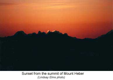 The
pair arrived at the summit at 9:25 just in time to watch the sun set in
a fiery blaze behind Rugged Mountain in the Haihte Range on the west coast.
They spent ten minutes enjoying the view and having a snack and a drink
before moving on to the south summit a kilometre away. Although the north
summit is thirteen feet higher than the southern, it is the south summit
that is considered the main summit and the site where the surveyors placed
their survey marker. Since DeVoe in 1913 the only other recorded ascents
were by surveyors: Norman Stewart in 1936 and Alfred
Slocomb in 1947.
The
pair arrived at the summit at 9:25 just in time to watch the sun set in
a fiery blaze behind Rugged Mountain in the Haihte Range on the west coast.
They spent ten minutes enjoying the view and having a snack and a drink
before moving on to the south summit a kilometre away. Although the north
summit is thirteen feet higher than the southern, it is the south summit
that is considered the main summit and the site where the surveyors placed
their survey marker. Since DeVoe in 1913 the only other recorded ascents
were by surveyors: Norman Stewart in 1936 and Alfred
Slocomb in 1947.
From the main summit there was still another three and a half kilometres to the southern end of the summit ridge. Again the traverse was easy and by 11:15 they were ready to descend off the ridge into the bush and down to the highway but first they had to get their headlamps out as the evening light had diminished. Two thirds of the way down they broke out of the forest into old logging slash but in the darkness they were unable to pick the best line and stumbled straight down towards the logging roads. Neither of them took the usual perverse pleasure in thrashing through the slash as their focus was on the headlights of the vehicles presumably on their way home to a comfortable bed. Finally at 1:25 A.M. they arrived on the highway beside Crest Creek Crags, a popular rock-climbing destination on the island, and were able to begin relaxing from the eight and a quarter hour traverse.
Prominent early explorers and surveyors often fade into obscurity but having their name immortalized on a mountain reminds people of the contribution they have made in their field. In 1923 in the centre of Strathcona Provincial Park a peak was named in honour of William Fowler DeVoe. Located between the Golden Hinde and Elk Pass the peak rises beside a saddle that is travelled as part of the Phillips Ridge/Elk River traverse through the park. In all probability it was first climbed by W.R. Kent, W.W. Urquhart and Einar Anderson sometime in 1913/14 while they also worked surveying and photographing Strathcona Park. Of modest height (1,710m) Mount DeVoe is an easy scramble but is rarely climbed; however, as with the view from any summit, it is worth the extra half an hour to make the climb.
DeVoe
had a promising future in front of him and the
profession of Land Surveyors were shocked that
one of their youngest and brightest members
was lost after such a short career. His contribution
to mapping the mountains of Vancouver Island,
and specifically Strathcona Provincial Park,
was significant. The names William DeVoe, his
father Judson and brother Heber, should never
be forgotten as they are now part of the history
of the mountains on Vancouver Island.
How to order | | About the Author || Links || Home
Contact:
Copyright ©
Lindsay Elms 2001. All Rights Reserved.
URL: http://www.beyondnootka.com
http://www.lindsayelms.ca