Island Stories:
![]() Danzig
Mine
Danzig
Mine
![]() Zeballos
Iron Mine
Zeballos
Iron Mine
![]() Conuma
Peak 1910
Conuma
Peak 1910
Alexandra Peak
Argus Mountain
Bate/Alava Sanctuary
Beaufort Range
Big Interior Mtn
Big Interior Mtn 1913
Part 1
Part 2
Bolton Expedition 1896
Cliffe Glacier
Clinton Wood
Comox Glacier
Comox Glacier 1922
Comox Glacier 1925
Comstock Mtn
Conuma Peak
Copper King Mine
Crown Mtn
Elkhorn 1912
Elkhorn 1949
Elkhorn 1968
Eugene Croteau
Golden Bullets
Golden Hinde 1913/14
Golden Hinde 1937
Golden Hinde 1983
Harry Winstone Tragedy
Jack Mitchell
Jim Mitchell Tragedy
John Buttle
Judges Route
Koksilah's Silver Mine
Landslide Lake
Mackenzie Range
Malaspina Peak
Mariner Mtn
Marjories Load
Matchlee Mountain
Mount McQuillan
Mt. Albert Edward
Mt. Albert Edward 1927
Mt. Albert Edward 1938
Mt. Becher
Mt. Benson 1913
Mt. Benson
Mt. Doogie Dowler
Mt. Colonel Foster
Mt. Hayes/Thistle Claim
Mt. Maxwell
Mt. Sicker
Mt. Tzouhalem
Mt. Whymper
Muqin/Brooks Peninsula
Nine Peaks
Queneesh
Ralph Rosseau 1947
Rosseau Chalet
Ralph Rosseau Tragedy
Rambler Peak
Red Pillar
Rex Gibson Tragedy
Sid's Cabin
Steamboat Mtn
Strathcona Park 1980's
The Misthorns
The Unwild Side
Victoria Peak
Waterloo Mountain 1865
Wheaton Hut/Marble Meadows
William DeVoe
Woss Lake
You Creek Mine
Zeballos Peak
Other Stories:
Sierra
de los Tuxtlas
Antarctica
Cerro del Tepozteco
Citlaltepetl
Huascaran
Mt. Roraima
Nevada Alpamayo
Nevada del Tolima
Nevado de Toluca
Pico Bolivar
Popocatepetl
Uluru/Ayers Rock
Volcan Purace
Volcan San Jose
Biographies
Island 6000
Cartoons
Order the Book
Contact Me
Links

Mount McQuillan
and China Creek:
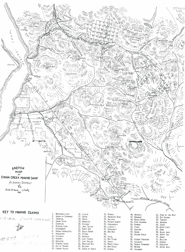
Gold Mines and Mining Claims
by Lindsay
Elms
 |
Mount
McQuillan/China Creek - History
The country adjacent to the Alberni Inlet is extensively mineralized.
Copper mineralization of the contact metamorphic type was predominantly
found on the southern section south of the Nahmint River on both sides
of the inlet while gold mineralization is characteristic of the country
east of the northern part of the inlet, specifically between Corrigan
Creek and China Creek. Considerable activity in placer-mining was carried
out as early as 1862, principally by the Chinese who were making a living
working China Creek for "flour" gold. A placer gold-deposit
is formed by the natural concentration into a stream of the eroded products
of gold-bearing rocks located in outcrops nearby. The process of mining
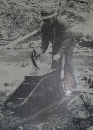
this "flour" gold was principally done with the use of the "shoe-rocker",
a piece of equipment that one man alone could work but two were more efficient,
with one shoveling in the gravel or mud and another doing the rocking
while watching the bottom to see if gold particles were being trapped.
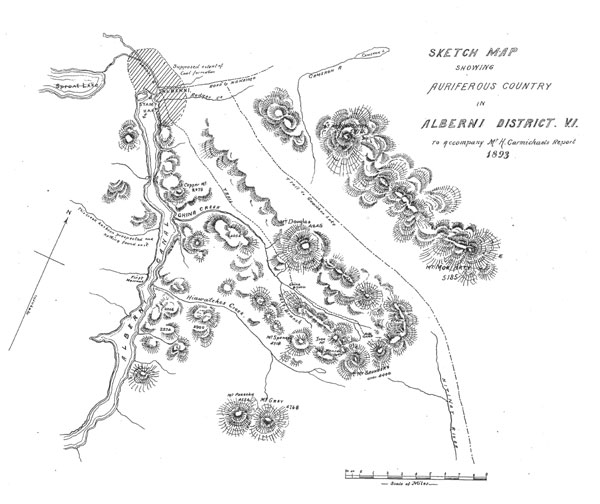
In a September 1895 report to the Minister of Mines for British Columbia,
William J. Sutton wrote:
China Creek has been worked for its alluvial gold as far back as 1862, principally by Chinamen, and has yielded about $40,000 by the most primitive methods, the pan, shovel, rocker, and sluice box. ... It must not be overlooked that placer gold has been deposited by a natural process of concentration by an extensive erosion of the surrounding country, and is not entirely depended upon a finger index to the extent of the gold yet remaining in the hills.
Starting from the Alberni Settlement, where a number of pioneers are busy clearing land in that fertile valley, China Creek is reached by a good pack trail, which passes over a comparatively level valley, along which a good wagon road could be easily built. The trail strikes China Creek about eight miles from the Alberni Settlement, opposite the Cataract Hydraulic Claim, and then follows the bank of China Creek up to its source, the Golden Eagle Basin.
Post 1890 mining at China Creek changed when large companies, directors and shareholders became involved and expensive equipment was utilized. There were a number of hydraulic leases on China Creek including the Duke of York, Prince of Wales, Cataract and Constance. These operations were a high pressure form of placer mining in which water was brought by pipes or flumes into a pipeline at the end of which is a nozzle called a "monitor" that when trained on banks of gold-bearing gravels, washed the gravels down ready to be sluiced. By "hydraulicing," companies could move immense amounts of gravel per day, however, by 1897 the last lease, the Duke of York, shut down when it could no longer pay for itself. Such extensive workings required many workers and had all the appearances of a little town: workers' houses, stables, an assay office and a blacksmith shop. After the Duke of York shut down only hard rock lode mining continued.
In the Golden Eagle Basin at the head of China Creek, gold-quartz veins were found and staked in 1892 and within a short time claims on Mineral Hill (the slopes adjacent to Mineral Creek) and in the King Solomon Basin at the head of McQuillan Creek (the south branch of China Creek) were staked. The property at the head of Granite Creek (now Corrigan Creek) was staked in 1898 and claims up the Franklin River were staked between 1896 and 1899.
By 1896 an entrepreneur named Robert (Bobby) DeBeaux had built a log structure at the end of China Creek Road, on the junction of Mineral Creek and China Creek. It became known as the "Hotel DeBeaux" and included horse stables, a bar room and sleeping accommodation. It operated until 1898 or 99, to accommodate not only the men working in the nearby Alberni-Consolidated Mine and Stamp Mill but as a halfway house for those prospectors working at nearby mines and for any additional men hired temporarily for large jobs. With a dozen other more or less developing mines, a common sentiment emphasized the need for a post office, the feeling being there was sufficient number of men employed to warrant such an institution, however, no post office was ever built. Although good gold values were found in places, there was nothing spectacular and the area didn't boom the way the Cariboo did in the 1860's or Zeballos in the 1930's.
All the gold-bearing claims are located predominantly around Mount McQuillan at the headwaters of four rivers: China Creek, Franklin River (formerly Hiawatches Creek), Nitinat River and Rift Creek. Mount McQuillan, at 1,575m, is the highest point of land directly south of Mount Arrowsmith and immediately to the east of the Alberni Inlet. However, on a sketch map drawn by the geologist Hebert Carmichael in 1893 the peak appears as Mount Saunders (after either Henry M. Saunders a Victoria businessman or his brother Fred Saunders, who ran his brothers store in Alberni) as it does again on an 1895 sketch map, but by then Mount McQuillan was marked as the lower summit immediately to the southeast of Father and Son Lake. In March 1947 the highest point was officially adopted as Mount McQuillan after Frank McQuillan, an Alberni resident in the 1890's who worked various jobs including a farmer, manager of the Alberni post office for a time, and the first manager of the Duke of York mine. As a prospector, he uncovered a copper deposit at Uchucklesit Inlet. The names of many of the adjacent mountains were already sketched on the 1895 map including Mount Douglas (now Douglas Peak), Limestone Mountain, Mount Patlicant, Mount Underwood, Hiwatchas Mountain, Logan Peak, Mount Spencer, McKinlay Peak and McLaughlin Ridge.
In the 1930's the claims on Mineral Creek were the most active and were reached by a 1½ mile trail from the logging-railway line of the Alberni-Pacific Lumber Company which ran from Port Alberni. Today logging roads give easy access up the Franklin River to Father and Son Lake and the Northwest Ridge of Mount McQuillan; Museum Creek into the Rift Valley and up the Panther Main to the southern aspect and South Ridge of the mountain; China Creek to the Golden Eagle Basin and McQuillan Creek to King Solomon Basin and the North Ridge, and to the mine site on Mineral Creek. Unfortunately access up China Creek is restricted due to the valley being the watershed for Port Alberni and a gate at the entrance to China Creek is usually locked when timber workers have finished in the valley for the day.
 |
Golden
Eagle Mine - China Creek
The Golden Eagle claim was staked in the fall of 1892 by Archie McLaughlin,
Thomas Hennesy and William Ethridge when they pushed up to the head of
China Creek in search of gold bearing quartz veins. The claim was subsequently
bonded by an English syndicate who undertook considerable work. By 1895
the four drift-adits on the vein had been driven and in 1896 the long,
low-level adit was driven from a point beyond the reach of destructive
snow slides. This latter adit, although driven for 2,100 feet, never intersected
the vein.
The Golden Eagle workings are between elevations of 2,279 and 2,990 feet at the head of China Creek. They are near the timber line at the base of steep, rocky bluffs that extend up to the eastern peak of Mount McQuillan. Initially a pack-horse trail led to the workings all the way up the valley but by the 1930's motor vehicles could drive to the mouth of McQuillan Creek and then follow an abandoned logging-railroad 3 miles to the mine cabin. In 1897 an explosion at the Golden Eagle marked the first fatalities in the mining industry when William Dixon and William Sareault were killed when attempting to dry out two sticks of dynamite in a pan on top of the stove.
Further claims (1941) known as the B and K are on the divide between China Creek and the East Fork of the Nitinat River near Summit Lake. The cabin was reached by a climb of 1,500 feet along a steep and narrow foot-trail.
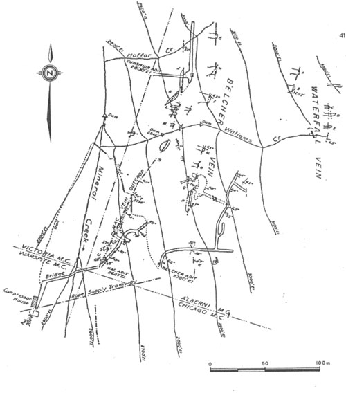
Vancouver
Island Gold Mine - Mineral Creek
On the south side of McLaughlin Ridge, Mineral Creek descends steeply
from a tarn-studded timbered plateau to China Creek. In the course of
2 kilometres Mineral Creek surges down 800 metres in a narrow defile.
In summer the creek can become a mere trickle while in winter the flow
is copious enough to move huge logs. Mineral Creek saw prospectors searching
its rocky outcrops for indications of gold or silver in its veins in the
early 1890's. Development of what was to eventually become known as the
Yellow claim began in 1895 when the original 4 claims: Alberni, Chicago,
Warspite and Victoria were staked. James Dunsmuir acquired the interest,
installed a 3 stamp mill near DeBeaux's Hotel but only held the interest
for two years. Then an English Company acquired and operated the mine
for another two years. From 1896 to 1898 a relatively minor amount of
tunneling was carried out yielding about 32 tons of ore, and in 1898 a
10 ton per day, 8 stamp mill was installed by the Victoria Metallurgical
Works for the Consolidated Alberni Mining Co. The following year work
halted.
The mine
lay dormant until 1933 when R.W. Williams leased the reverted Crown Grants
which he then optioned to Vancouver Island Gold Mine Ltd. In 1934 a tunnel
was driven into the hillside at a cost of $15,000 and between 1834 and
1936 the company employed an average of 10-12 men for the 3 years. From
1933 to 1936 a total of 403 tons of ore was mined and a 35 ton mill was
constructed beside the creek at around the 800m level. In 1936 the mine
was closed down but in 1939 a crew of four men was engaged to clean up
and repair the lower and upper Mac adits and a small shipment of 48 tons
of ore was shipped to the Tacoma Smelter.
Three main veins in the Yellow Claim were found containing gold: Waterfall Vein, Belcher Vein and Mac Vein. Extensive adits were dug following the Mac Vein (Mac Adit) and the Belcher Vein (Belcher and Dunsmuir Adits) while only surface digging occurred at the Waterfall Vein. Activity at the sites has depended on the fluctuations in the price of gold.
During the period 1963 to 1966, Gunnex Ltd. carried out a regional mapping program with some prospecting and silt sampling. They compiled a list of all known mineral occurrences in the area and visited many of them including the Thistle Mine, Black Panther Mine, Havilah Mine, King Solomon Basin and Golden Eagle Basin. Some sampling was carried out on Mineral Creek in 1964.
Ten years later Keywest Resources Ltd. carried out surface and underground mapping and sampling in 1973-74 and then in 1976 Western Mines Ltd. carried out reconnaissance geological mapping and soil sampling in the area.
Silver Clouds Mine Ltd. has owned the property since 1979. An access road was constructed to the mine that followed the old prospectors trail and further exploration was carried out in 1981 and 1983. Soil samplings in showed gold values greater than 100 ppb and in the old workings it was as high as 1000 ppb. The high gold values where shown to be associated with high arsenic. Mapping and reconnaissance soil sampling continued in 1985 and further geological, geochemical and geophysical surveys were recommended to define drill targets.
Since then there has been no evidence of any further work undertaken and the adits remain but with locked gates. Old trails criss-cross the steep slopes leading to various sites where digging was started and signs of the old tramway can still be found.
 |
King Solomon/Havilah
Gold Mines - McQuillan Creek
Although the King Solomon claim on McQuillan Creek (the south fork of
China Creek) was first staked in 1893, the Havilah Mine located at the
head of McQuillan Creek (3,550ft) in the King Solomon Basin was more productive.
In August 1934 the first two claims were staked and in February 1936 the
remainder was staked by Walter Harris of Port Alberni. At the time the
property was reached by the abandoned railway-grade of the Alberni-Pacific
Logging Co. which was suitable for automobiles to the junction of McQuillan
and China Creek. At first a pack-horse trail led from the junction of
the two creeks for 4 miles but by the end of 1936 a narrow-gauge road
was constructed covering 3 miles with the last 1 mile to the cabin still
being traveled by pack-horse as it was too steep for vehicles.
The mine is described as two workings: The lower Gillespie Vein at 3,500 feet and the upper Alberni and McQuillan Veins between 4,000 and 4,300 feet. By the end of 1936, 7 tons of ore was shipped out yielding 15 oz. of gold and 6 oz. of silver. Between July 1938 and August 1939, 1038 tons of ore was shipped to the Tacoma Smelter from the Gillespie Vein where an average of 18 men were employed.
Some work was undertaken in ....
Thistle
Mine - Franklin River
The Thistle Mine at the head of Franklin (Hiwatches) River consists of
5 Crown grants which were staked between 1896 and 1899. A camp was constructed
at an elevation of 2,150 feet and the workings were between 2,460 and
2,750 feet. Initially there were two trails to the mine. The first was
from Underwood Cove on the Alberni Inlet and the second by trail from
DeBeaux's Hotel on China Creek via Williams creek and Lizard Lake. Access
to the property was still by trail in 1901 when a San Francisco syndicate
took over the property. They did considerable development work and undertook
to build a wagon road from Underwood Cover on the Alberni Inlet to the
mine. Although the syndicate had up to 200 men working for about 2 months,
bad weather prevented their building the road for more than 6 of the 12
miles from the beach. Very little mining was done from then until 1938,
when the property was acquired by the United Prospectors Ltd of Victoria.
This company completed the road to the mine, following, in part, abandoned
logging-railroads, and drove the adits to their present faces. That year
all work was of the open-cut and "glory hole" (open pit) method
of mining and 80 tons of ore was shipped out. However, eventually between
1938 and 1942, 6867 tons of ore was shipped containing 2667 oz. of gold,
1667 oz. of silver and 626,556 lbs. of copper.
Black
Panther Mine - Rift Creek
The Black
Panther Mines were staked by Walter Harris in 1936 and are located at
an elevation between 2,450 and 2,700 feet at the head of the West Fork
(Rift Creek) of the Nitinat River. In 1939, a crew of 4 men was employed
to construct a trail from the Thistle Mine, in the Franklin River, over
the saddle between Mount McQuillan and Limestone Mountain to the two mines
where two roomy cabins were built. In 1941 the mines were operated under
option by Pioneer Gold Mines of BC, and an average of 11 men worked from
April to the end of the year. A substantial log cabin was used as a cook-house
and dinning-room, while the men were accommodated in a frame building
and 3 tents partly of frame construction.
 |
 |
|
Mount
McQuillan and heawaters of McQuillan Creek
|
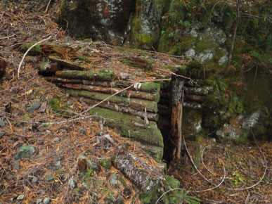
Mine
entrance on Mineral Creek
|
 |
 |
|
Old
placer miner using a rocker in China Creek
|
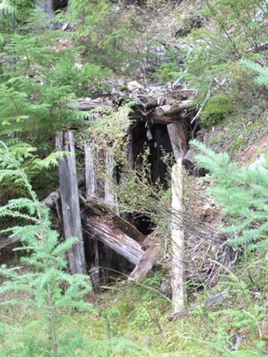
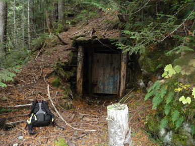
Mine
entrance on Mineral Creek
|
 |
 |
|
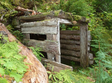
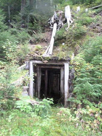
Mine
entrance on Mineral Creek
|
Mine
entrance on Mineral Creek
|
 |
 |
|
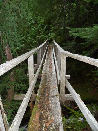
Old
bridge on Mineral Creek
|
Mine
entrance on Mineral Creek
|
How to order | | About the Author || Links || Home
Contact:
Copyright ©
Lindsay Elms 2001. All Rights Reserved.
URL: http://www.beyondnootka.com
http://www.lindsayelms.ca