Island Stories:
![]() Danzig
Mine
Danzig
Mine
![]() Zeballos
Iron Mine
Zeballos
Iron Mine
![]() Conuma
Peak 1910
Conuma
Peak 1910
Alexandra Peak
Argus Mountain
Bate/Alava Sanctuary
Beaufort Range
Big Interior Mtn
Big Interior Mtn 1913
Part 1
Part 2
Bolton Expedition 1896
Cliffe Glacier
Clinton Wood
Comox Glacier
Comox Glacier 1922
Comox Glacier 1925
Comstock Mtn
Conuma Peak
Copper King Mine
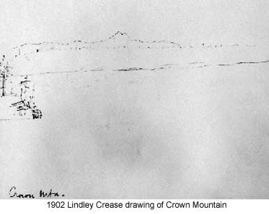
Crown Mtn
Elkhorn 1912
Elkhorn 1949
Elkhorn 1968
Eugene Croteau
Golden Bullets
Golden Hinde 1913/14
Golden Hinde 1937
Golden Hinde 1983
Harry Winstone Tragedy
Jack Mitchell
Jim Mitchell Tragedy
John Buttle
Judges Route
Koksilah's Silver Mine
Landslide Lake
Mackenzie Range
Malaspina Peak
Mariner Mtn
Marjories Load
Matchlee Mountain
Mount McQuillan
Mt. Albert Edward
Mt. Albert Edward 1927
Mt. Albert Edward 1938
Mt. Becher
Mt. Benson 1913
Mt. Benson
Mt. Doogie Dowler
Mt. Colonel Foster
Mt. Hayes/Thistle Claim
Mt. Maxwell
Mt. Sicker
Mt. Tzouhalem
Mt. Whymper
Muqin/Brooks Peninsula
Nine Peaks
Queneesh
Ralph Rosseau 1947
Rosseau Chalet
Ralph Rosseau Tragedy
Rambler Peak
Red Pillar
Rex Gibson Tragedy
Sid's Cabin
Steamboat Mtn
Strathcona Park 1980's
The Misthorns
The Unwild Side
Victoria Peak
Waterloo Mountain 1865
Wheaton Hut/Marble Meadows
William DeVoe
Woss Lake
You Creek Mine
Zeballos Peak
Other Stories:
Sierra
de los Tuxtlas
Antarctica
Cerro del Tepozteco
Citlaltepetl
Huascaran
Mt. Roraima
Nevada Alpamayo
Nevada del Tolima
Nevado de Toluca
Pico Bolivar
Popocatepetl
Uluru/Ayers Rock
Volcan Purace
Volcan San Jose
Biographies
Island 6000
Cartoons
Order the Book
Contact Me
Links

Crown
Mountain:
1910
Exploratory Survey Trip
by Lindsay Elms
 The
interior of Vancouver Island has even today restricted access except for
those with the skills and tenacity to combat not only the weather but
the rugged nature of the terrain. In the early days it took a special
breed to explore the uncharted regions of a new colony. Initial colonization
of Vancouver Island occurred in 1843 when a fort was constructed in Victoria
Harbour. Settlements began appearing in places on the east coast where
significant coal deposits were located but it was awhile before people
had the time and inclination to explore the interior. The first explorers,
Hamilton Moffat, Adam
Horne, Joseph
Pemberton, Phillip Hankin and Charles Wood, traversed Vancouver
Island in different locations, in most cases following ancient native
trading routes. In the 1860's Robert
Brown and John
Buttle explored sections of the interior but it wasn't until
the mid 1890's that the more remote central regions were explored by Reverend
William Bolton and John Laing. The explorer's reports were
submitted to the Provincial Government in Victoria and gradually accumulated
into a substantial file.
The
interior of Vancouver Island has even today restricted access except for
those with the skills and tenacity to combat not only the weather but
the rugged nature of the terrain. In the early days it took a special
breed to explore the uncharted regions of a new colony. Initial colonization
of Vancouver Island occurred in 1843 when a fort was constructed in Victoria
Harbour. Settlements began appearing in places on the east coast where
significant coal deposits were located but it was awhile before people
had the time and inclination to explore the interior. The first explorers,
Hamilton Moffat, Adam
Horne, Joseph
Pemberton, Phillip Hankin and Charles Wood, traversed Vancouver
Island in different locations, in most cases following ancient native
trading routes. In the 1860's Robert
Brown and John
Buttle explored sections of the interior but it wasn't until
the mid 1890's that the more remote central regions were explored by Reverend
William Bolton and John Laing. The explorer's reports were
submitted to the Provincial Government in Victoria and gradually accumulated
into a substantial file.
In 1909 the Premier of British Columbia, Sir Richard McBride, became interested in establishing a park in the Province after receiving a letter from the Governor General of Canada, Albert Grey, 4th Earl Grey of England. The Earl was enthusiastic about seeing the area around Windermere developed into a national park as he had spent a "delightful holiday" in the region, however, it was Vancouver Island that piqued McBride's interest. McBride was impressed with all the glowing reports from the island's explorers about the Buttle Lake region and by June 2, 1910 McBride's Deputy Minister of Lands, Robert Renwick had set aside a block of wilderness for such purposes.
A notice appeared in Victoria's Daily British Colonist newspaper that all the Crown lands embraced within a triangle of land that commenced at the summit of Crown Mountain was to be 'reserved for Government purposes.' From Crown Mountains summit the boundary line followed due south to a point on the Esquimalt and Nanaimo Railway Land Belt one hundred miles from Muir Creek, another due east to the western boundary of the E & N Railway Belt and finally northwest back to the summit of Crown Mountain. In all an area of seven hundred and eighty-five square miles was set aside. McBride proposed that it be named Strathcona Park after the Right Honorable Lord Strathcona, Donald Alexander Smith. Smith had hammered in the last spike of the Canadian Pacific Railway at Craigellachie in interior British Columbia.
 Interest
was high in the McBride government for the new park and the Minister of
Lands, Price
Ellison, decided to personally have a look at the proposed
park. At the age of fifty-six Ellison still considered himself to be made
of the same mettle as a younger, fitter person and was determined to lead
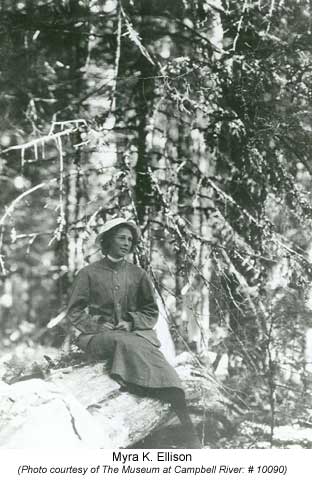
the expedition himself. Accompanying him was his twenty year old daughter
Myra,
the only female on the expedition.
Interest
was high in the McBride government for the new park and the Minister of
Lands, Price
Ellison, decided to personally have a look at the proposed
park. At the age of fifty-six Ellison still considered himself to be made
of the same mettle as a younger, fitter person and was determined to lead
the expedition himself. Accompanying him was his twenty year old daughter
Myra,
the only female on the expedition.
On July 5, Ellison's party embarked on what was called the 1910 Exploratory Survey Trip leaving Victoria on board the C.P. Steamship Queen City. The boat ride took them first to Vancouver and then onto Campbell River where they arrived early on the morning of July 7. While steaming up the Straits of Georgia the mountains of Vancouver Island were clearly visible, but as yet they were unable to identify the individual peaks. From what they could see of the rugged nature of the mountains they realized their trip was not going to be easy.
Upon arrival at Campbell River, Myra and Price Ellison were driven by buckboard up to McIvor Lake and Elk Falls by Mr. Hannah, the bar tender at the Willow Hotel. From the lake Crown Mountain could be clearly seen. Although it looked extremely difficult they hoped that closer inspection would reveal a feasible route to the summit as they decided this would be a suitable climbing objective.
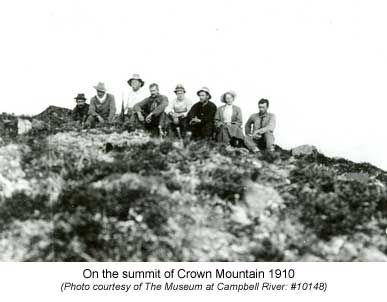
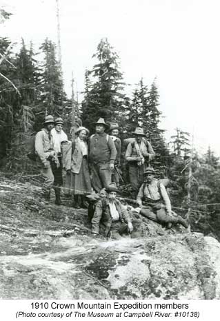 It
was a large party consisting of twenty-three people, led by Price Ellison
who became affectionately known as 'The Chief,' that headed off from the
Willows Hotel on July 10. Amongst them were Colonel William J.H. Holmes,
a Provincial Land Surveyor, Harry McClure Johnson, the Chief's nephew
and reporter, and Reverend William Bolton and his nineteen year old son,
Gerard. William Bolton was the historian of the party and was to be the
guide over the great divide to Great Central Lake and Alberni after the
ascent of Crown Mountain. He was one of the few known persons to have
penetrated the interior of the island where they were going: the local
natives refused to enter the area because they believed it to be the hunting
ground of the evil spirits called Massache Ikta.
It
was a large party consisting of twenty-three people, led by Price Ellison
who became affectionately known as 'The Chief,' that headed off from the
Willows Hotel on July 10. Amongst them were Colonel William J.H. Holmes,
a Provincial Land Surveyor, Harry McClure Johnson, the Chief's nephew
and reporter, and Reverend William Bolton and his nineteen year old son,
Gerard. William Bolton was the historian of the party and was to be the
guide over the great divide to Great Central Lake and Alberni after the
ascent of Crown Mountain. He was one of the few known persons to have
penetrated the interior of the island where they were going: the local
natives refused to enter the area because they believed it to be the hunting
ground of the evil spirits called Massache Ikta.
It took over a week for the several tons of supplies and equipment to be moved to Upper Campbell Lake where a base camp was established for the expedition. A wagon carried their provisions to McIvor Lake and then they canoed through the sloughs to Lower Campbell Lake. From the head of the lake they poled up the Campbell River to Upper Campbell Lake. Although the Quinsam Trail existed from Lower to Upper Campbell Lake, the expedition believed their provisions could be moved faster on the river then by land. While on the Campbell River Price Ellison upset the canoe he was in and received a knee injury that was to aggravate him throughout the rest of the trip.
After several days at Upper Campbell Lake, Ellison selected those who were to climb Crown Mountain with him and Myra. Included in the nine were Colonel Holmes, Harry Johnson, James Hasworth, Charles Haslam, Frank Ward, Lionel Hudson and James (Scotty) Twaddle, the cook. Twaddle, who was originally from Glasgow, was one of the most popular men on the trip. Trained as a mineral assayer/prospector in his native Scotland, Twaddle immigrated to Canada where he was able to use his skills in a young country whose natural resources were only just beginning to be tapped.
The climbing party of nine left Upper Campbell Lake on July 24 and proceeded northwest up over the side of Mount Flannigan to the ridge running towards what they called Myra Mountain (now called Mount Evelyn.) From there they had a grand view of Crown Mountain and were able to plot their course for the final climb of the mountain.
After four more days of travelling up and down valleys they were within striking distance of the summit. Anticipation for the next day's climb was high. They sat around the campfire talking and telling stories longer than they ought: sleep was not foremost on their minds.
 Dawn
came early the next morning (July 29) and the party was able to get away
before 5:30 A.M. Climbing ropes were left behind, partly due to their
weight, but also because none of the group were proficient with their
use. They recognized that the incorrect use of ropes could lead to a false
security. Holmes acknowledged that: "…if we come to where we
could not pull ourselves up without the ropes, he would turn back."
As they left camp in the crisp, cool air of the dawn, a quietness descended
over the group. There were two things they were hoping for on this summit
day: the weather would remain clear and calm, and that there would be
no technical difficulties to encounter.
Dawn
came early the next morning (July 29) and the party was able to get away
before 5:30 A.M. Climbing ropes were left behind, partly due to their
weight, but also because none of the group were proficient with their
use. They recognized that the incorrect use of ropes could lead to a false
security. Holmes acknowledged that: "…if we come to where we
could not pull ourselves up without the ropes, he would turn back."
As they left camp in the crisp, cool air of the dawn, a quietness descended
over the group. There were two things they were hoping for on this summit
day: the weather would remain clear and calm, and that there would be
no technical difficulties to encounter.
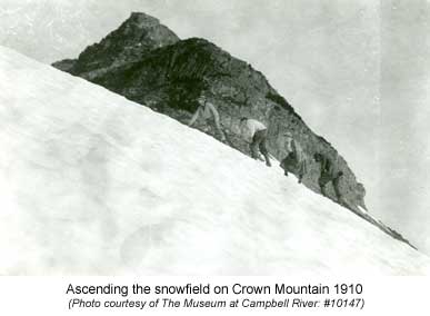
 The
party made good time until four hundred feet from the summit where they
came up against a high precipice that looked impossible. Upon inspection
the west side looked even worse. They checked to the east and found that
if they could pick their way across the main snowfield and get onto the
northeast side, the way to the summit was clear. The party feared crossing
the snowfield would put them in danger of snow-slides but it was the only
way to the summit. The crossing was tense with everyone afraid to even
whisper lest it unleash a deathly avalanche upon them. Once everyone was
safely across the snow, there was a short rock step to negotiate and then
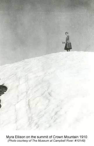
Myra Ellison took her place as the first person upon the summit.
The
party made good time until four hundred feet from the summit where they
came up against a high precipice that looked impossible. Upon inspection
the west side looked even worse. They checked to the east and found that
if they could pick their way across the main snowfield and get onto the
northeast side, the way to the summit was clear. The party feared crossing
the snowfield would put them in danger of snow-slides but it was the only
way to the summit. The crossing was tense with everyone afraid to even
whisper lest it unleash a deathly avalanche upon them. Once everyone was
safely across the snow, there was a short rock step to negotiate and then
Myra Ellison took her place as the first person upon the summit.
In a brass cartridge, the following account was placed within the cairn that the party built:
Crown Mountain.
Ellison Peak,
Friday, July 29th, 1910A party of the Provincial Government Expedition, headed by the Chief Commissioner of Lands, the Hon. Price Ellison, M.P.P. for the Okanagan District, and organized for the purpose of exploring the region surrounding Crown Mountain and Buttle's Lake with a view of setting aside the same as a Provincial Park, reached the summit this day, at 7:45 a.m. Miss Myra King Ellison, the Chief's daughter, was first to reach the topmost point, and there waved the Union Jack. The party ate lunch. The at 8:23 o'clock, with the words, "I hereby name you Ellison Peak, Crown Mountain." Miss Ellison broke a bottle of Champagne over a cairn of rocks erected by the party, at the same time the Union Jack over the Star Spangled Banner of the United States being held above her head by the Chief. Then the Chief led in singing, "God save the King," and H. McC. Johnson in singing the first verse of "My Country, 'Tis of Thee."
 Also
placed in the cairn were the signatures of each member and an interesting
assortment of two newspapers, a baseball pass made out to Frank Ward and
his wife and a butter tin containing some coins. All that remains nowadays
of their visit is the rock cairn, built up over the years by subsequent
climbers.
Also
placed in the cairn were the signatures of each member and an interesting
assortment of two newspapers, a baseball pass made out to Frank Ward and
his wife and a butter tin containing some coins. All that remains nowadays
of their visit is the rock cairn, built up over the years by subsequent
climbers.
After descending safely they debated whether to return to base camp via the same route or to go down the Southeast Ridge of the mountain to the north fork of the Elk River (Tlools Creek) and follow it to Upper Campbell Lake. Holmes decided to take Lionel Hudson and return the way they came, while the rest of the party took the alternate route down.
At the end of the second day Ellison and his party came across the rest of the expedition members, who had stayed behind, camped at the Elk River. That evening over an elaborate feast of Ox-tail soup, mutton a la Spanish, peas and corn, and a peach pie with evaporated milk, they were able to recount the tales of their successful climb of Crown Mountain. Price Ellison obviously extremely proud of the effort of his daughter Myra.
The next several days were spent catching some of the abundant trout in the lakes and drying them in preparation for the second part of their journey: the hike from Buttle Lake over the divided to Port Alberni.
On August 8 the party arrived at the mouth of Price Creek at the southern end of Buttle Lake where they were met by Captain Roberts. Robert's was a surveyor from Port Alberni who had been employed by Ellison to blaze out a trail from Great Central Lake over the divide to Buttle Lake. Robert's party had completed the task the night before and came out of the bush to greet the Ellison party.
The next day Ellison's party began following the blazed trail up Price Creek. It was in poor shape and after a couple of miles Reverend William Bolton, the man who fourteen years earlier had travelled in the same vicinity as part of his north/south traverse of Vancouver Island with John Laing, decided to return to Buttle Lake. He was no longer up to the arduous task as clerical duties had consumed his time and he was not in the physical shape to undertake the journey.
Roberts had placed posts every mile of the route so the expedition knew how far they had to travel and at what mile to expect difficult terrain. They found the going hard and by mile eleven they finally reached the main divide. They made their camp for the night on the shores of a small lake (Green Lake) situated at the base a large glacier that tumbled off the surrounding mountains (Mount Septimus, Mount Rosseau and the Misthorns.) The following day they crossed the lower reaches of the glacier and climbed a wide snow slope to the pass at the head of the valley. Reports and photographs suggest that the glacier had more snow back in those early days which may have worked to their advantage by keeping crevasses filled later into the season.
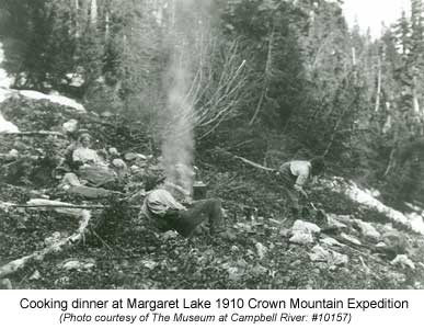 After
the glacier they descended to Margaret Lake (named in honour of McBride's
wife) and then on down to the Drinkwater Creek where a good prospectors'
trail led to Great Central Lake and eventually out to the Drinkwater Hotel
at the head of the lake. On August 12, the party arrived in Alberni where
it was hailed a great success. Ellison's report to the Government was
enthusiastic and he received the go ahead for the development of Strathcona
Park. On March 1, 1911, the area was officially designated as British
Columbia's first provincial park and the surveying of the boundary and
the mountains began.
After
the glacier they descended to Margaret Lake (named in honour of McBride's
wife) and then on down to the Drinkwater Creek where a good prospectors'
trail led to Great Central Lake and eventually out to the Drinkwater Hotel
at the head of the lake. On August 12, the party arrived in Alberni where
it was hailed a great success. Ellison's report to the Government was
enthusiastic and he received the go ahead for the development of Strathcona
Park. On March 1, 1911, the area was officially designated as British
Columbia's first provincial park and the surveying of the boundary and
the mountains began.
The 1910
Crown Mountain Exploratory Survey Trip certainly opened the island up
for mountaineering with the establishment of a Provincial Park of world
class. Climbers whose names were associated with the newly formed Alpine
Club of Canada soon came out to the island looking for new adventures
and unclimbed peaks; something that abounded on the island at this time.
As for Myra Ellison she was the first female climber on the island and
her stamina and determination proved to the male dominated sport that
women were capable of such arduous undertakings, even if they had to wear
a skirt.
How to order | | About the Author || Links || Home
Contact:
Copyright ©
Lindsay Elms 2001. All Rights Reserved.
URL: http://www.beyondnootka.com
http://www.lindsayelms.ca