Island Stories:
![]() Danzig
Mine
Danzig
Mine
![]() Zeballos
Iron Mine
Zeballos
Iron Mine
![]() Conuma
Peak 1910
Conuma
Peak 1910
Alexandra Peak
Argus Mountain
Bate/Alava Sanctuary
Beaufort Range
Big Interior Mtn
Big Interior Mtn 1913
Part 1
Part 2
Bolton Expedition 1896
Cliffe Glacier
Clinton Wood
Comox Glacier
Comox Glacier 1922
Comox Glacier 1925
Comstock Mtn
Conuma Peak
Copper King Mine
Crown Mtn
Elkhorn 1912
Elkhorn 1949
Elkhorn 1968
Eugene Croteau
Golden Bullets
Golden Hinde 1913/14
Golden Hinde 1937
Golden Hinde 1983
Harry Winstone Tragedy
Jack Mitchell
Jim Mitchell Tragedy
John Buttle
Judges Route
Koksilah's Silver Mine
Landslide Lake
Mackenzie Range
Malaspina Peak
Mariner Mtn
Marjories Load
Matchlee Mountain
Mount McQuillan
Mt. Albert Edward
Mt. Albert Edward 1927
Mt. Albert Edward 1938
Mt. Becher
Mt. Benson 1913
Mt. Benson
Mt. Doogie Dowler
Mt. Colonel Foster
Mt. Hayes/Thistle Claim
Mt. Maxwell
Mt. Sicker
Mt. Tzouhalem
Mt. Whymper
Muqin/Brooks Peninsula
Nine Peaks
Queneesh
Ralph Rosseau 1947
Rosseau Chalet
Ralph Rosseau Tragedy
Rambler Peak
Red Pillar
Rex Gibson Tragedy
Sid's Cabin
Steamboat Mtn
Strathcona Park 1980's
The Misthorns
The Unwild Side
Victoria Peak
Waterloo Mountain 1865
Wheaton Hut/Marble Meadows
William DeVoe
Woss Lake
You Creek Mine
Zeballos Peak
Other Stories:
Sierra
de los Tuxtlas
Antarctica
Cerro del Tepozteco
Citlaltepetl
Huascaran
Mt. Roraima
Nevada Alpamayo
Nevada del Tolima
Nevado de Toluca
Pico Bolivar
Popocatepetl
Uluru/Ayers Rock
Volcan Purace
Volcan San Jose
Biographies
Island 6000
Cartoons
Order the Book
Contact Me
Links

Muqin/Brooks
Peninsula:
Celebrating
a Dual Connection
by Lindsay Elms
For the first time in British Columbia's history a Provincial Park has been given a dual name that celebrates the First Nations' connection with the history and culture of the park. The landmark agreement was reached on July 13, 2009, between British Columbia and the Che:k'tles7et'h' peoples to rename Brooks Peninsula Provincial Park on the west coast of Vancouver Island to Muqin/Brooks Peninsula Provincial Park.
This agreement is intended to foster a strong foundation for the collaborative management of all of the parks and protected areas within the traditional territories of the Che:k'tles7et'h' peoples, said Barry Penner, the Environment Minister. It provides certainty, acknowledgement, and recognition of the local First Nations and the connection they have to these special areas. This step is one of many to recognize and increase their involvement in planning.
The B.C. government is partnering with the Che:k'tles7et'h,' members of the Ka:'yu:'k't'h'/Che:k'tles7et'h' First Nations, one of the five signatories of the Maa-nulth treaty, to rename Brooks Peninsula Provincial Park. The word Muqin means "The Queen" in the Nuu-Chah-Nulth language. The park also falls within the boundaries of the Quatsino First Nation, who support the renaming plan. This area is spiritually significant to these First Nations, and has long served as the traditional hunting and fishing grounds for the Che:k'tles7et'h' peoples.
The Maa-nulth treaty between B.C., Canada and First Nations including the Ka:'yu:'k't'h'/Che:k'tles7et'h' First Nations recognizes the important role that they play in continuing their culture and connection to the land, said Aboriginal Relations and Reconciliation Minister George Abbott. This agreement exemplifies the provisions of the treaty for parks management and planning - working co-operatively regarding management of areas that are important to all British Columbians.
Muqin/Brooks Peninsula Provincial Park is the second-largest protected area on Vancouver Island and juts out like a toe into the Pacific Ocean with its old growth coastal rain forest-covered land. The park has one of the most unique landscapes on Vancouver Island as it largely escaped the impacts of the last ice age. It features a central ridge that gradually rises from sea level eastward to jagged, angular peaks reaching to heights over 900 metres. Windswept ridges support dwarfed vegetation due to the frequent high winds of winter storms. Salt marshes and bogs on the northwest side of the peninsula are unique. Deeply incised cirques and steep U-shaped valleys are topped off by the steep, rocky summits of the Refugium Range, the central spine of the peninsula. The base of Mount Harris, one of the prominent peaks of Brooks Peninsula, is cloaked in thick forest which melds into a belt of krummholz (trees blasted into shrubbery by the ferocity of the winds), and is finally capped in bare rock. It is home to a variety of rare plant species and unique geologic formations, providing unparalleled opportunities for scientific study. The annual rainfall of the area is more than 350cm (140 inches) upon this forbidding and storm-battered stretch of land
The park is located north of the village of Kyuquot on northwest Vancouver Island, and is accessible primarily by boat from Fair Harbour in Kyuquot Sound or north from Quatsino Sound. It is 51,631 hectares (127,583 acres) in size and juts 20 kilometres into the Pacific Ocean and has a rugged and varied coastline, with long fjords and sandy beaches. The inland is seldom-explored and densely wooded with mostly old growth forest. The highest point is a sub-peak of Snowsaddle Mountain at 1143m (3,750ft) elevation. Mountains in the park, known as the Refugium Range, include Klaskish (963m or 3,159ft), Nunatak (930m or 3,051ft), and Doom Mountain (787m or 2,582ft). All the mountains over 700m on the peninsula were above the glaciers during the last ice age. These peaks are known as nunataks, an Inuit word which refers to a exposed, often rocky element of a ridge, mountain or peak not covered with ice or snow within (or at the edge of a) an ice field or glacier.
Muqin/Brooks Peninsula is infrequently visited; its surrounding waters however provide superb kayaking and canoeing. It is entirely undeveloped and has no marked trails and no facilities. Camping is permitted anywhere in the park, but made complicated due to the remoteness, difficulty of access, and lack of facilities. In 1778 the British explorer Captain James Cook called Brooks Peninsula the "cape of storms".
In the 1790's American trading ships visited Columbia's Cove, on the south shore of the peninsula, as it was well protected and offered a good beach for hauling out ships for repair. The Americans traded copper, iron and cloth for see otter pelts and land mammal furs. They also traded beads, fishhooks and other trinkets for food. Today sheltered anchorages are available in Nasparti and Ououkinsh Inlet in the southern part of the park and in Brooks Bay and Klaskish Inlet in the northern portion. Nearby Solander Island is an Ecological Reserve and access is prohibited.
Brooks Peninsula, know as "The Graveyard of the Pacific", claimed many ships over the years. In December 1885, the Hawaiian bark Thomas. R. Foster left Esquimalt Harbour with 1650 tons of coal for Honolulu but encountered a heavy southwest gale soon after leaving port and began taking on water. After attempting to reach Cape Flattery the crew then encountered a northeast gale and beached near Cape Cook. The crew managed to get to shore and survived for twenty-two days on mussels, crows, mice and seaweed until they were rescued. In May 1893 the Alaska schooner Jane Gray sailed from Seattle for Kotzebue Sound but in the early hours of the third day floundered and sank off Cape Cook. Of the sixty-one people on board thirty-six perished.
In 1899 an extensive iron-capping was discovered near Cape Cook, but was never mined. Various prospectors searched for gold near Cape Cook and six mining leases were staked on Amos and Gold Creeks. Although mineral exploration has continued almost to this day, it has been without success.
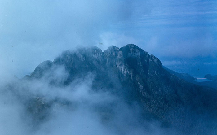
Whereas the coastal areas of Brooks Peninsula are thoroughly explored by various scientific studies, as well as visiting kayakers and boaters, much of the interior remains unexplored. In 1981 Dr. Richard Hebda, the curator of Botany and Earth History at the Royal British Columbia Museum, and several other botanists, explored the rugged interior of the peninsula and wrote a number of scientific papers on the region. During that trip Hebda named the most impressive peak on the peninsula Doom Mountain. It was so named because of the forbidding appearance of sheer cliffs, and because the mountain top was usually shrouded in cloud while the rest of the area was clear. The expedition also named many of the ponds, lakes and rivers on the peninsula after the plants and often used their Latin name. Harris Peak was named in 1937 by H.D. Parizeau of the Hydrographic Service after a sealing schooner captain Charles J. Harris.
|
Doom Mountain photo courtesy of John Gibson
|
 |
How to order | | About the Author || Links || Home
Contact:
Copyright ©
Lindsay Elms 2001. All Rights Reserved.
URL: http://www.beyondnootka.com
http://www.lindsayelms.ca