Island Stories:
![]() Danzig
Mine
Danzig
Mine
![]() Zeballos
Iron Mine
Zeballos
Iron Mine
![]() Conuma
Peak 1910
Conuma
Peak 1910
Alexandra Peak
Argus Mountain
Bate/Alava Sanctuary
Beaufort Range
Big Interior Mtn
Big Interior Mtn 1913
Part 1
Part 2
Bolton Expedition 1896
Cliffe Glacier
Clinton Wood
Comox Glacier
Comox Glacier 1922
Comox Glacier 1925
Comstock Mtn
Conuma Peak
Copper King Mine
Crown Mtn
Elkhorn 1912
Elkhorn 1949
Elkhorn 1968
Eugene Croteau
Golden Bullets
Golden Hinde 1913/14
Golden Hinde 1937
Golden Hinde 1983
Harry Winstone Tragedy
Jack Mitchell
Jim Mitchell Tragedy
John Buttle
Judges Route
Koksilah's Silver Mine
Landslide Lake
Mackenzie Range
Malaspina Peak
Mariner Mtn
Marjories Load
Matchlee Mountain
Mount McQuillan
Mt. Albert Edward
Mt. Albert Edward 1927
Mt. Albert Edward 1938
Mt. Becher
Mt. Benson 1913
Mt. Benson
Mt. Doogie Dowler
Mt. Colonel Foster
Mt. Hayes/Thistle Claim
Mt. Maxwell
Mt. Sicker
Mt. Tzouhalem
Mt. Whymper
Muqin/Brooks Peninsula
Nine Peaks
Queneesh
Ralph Rosseau 1947
Rosseau Chalet
Ralph Rosseau Tragedy
Rambler Peak
Red Pillar
Rex Gibson Tragedy
Sid's Cabin
Steamboat Mtn
Strathcona Park 1980's
The Misthorns
The Unwild Side
Victoria Peak
Waterloo Mountain 1865
Wheaton Hut/Marble Meadows
William DeVoe
Woss Lake
You Creek Mine
Zeballos Peak
Other Stories:
Sierra
de los Tuxtlas
Antarctica
Cerro del Tepozteco
Citlaltepetl
Huascaran
Mt. Roraima
Nevada Alpamayo
Nevada del Tolima
Nevado de Toluca
Pico Bolivar
Popocatepetl
Uluru/Ayers Rock
Volcan Purace
Volcan San Jose
Biographies
Island 6000
Cartoons
Order the Book
Contact Me
Links

Colombia: land of Juan Valdez coffee, brilliant green emeralds and the most sought after cocaine in the world, however, the country has more to offer for the adventurer who is not easily intimidated by machinegun-toting federal police and narco-terrorists. The mountains are a mecca for climbers although they do begin to taper off slightly in height when compared to the rest of South America. Nevertheless, the highest mountains in Colombia rise to 5,700 metres and are located in the north of the country in the Sierra Nevada de Santa Marta, while to the east bordering with Venezuela is the Sierra Nevada del Cocuy with peaks rising to over 5,300 metres. From the south at the border with Ecuador through to the central region of Colombia are some of the world's most active volcanoes: Volcán Galeras, Volcán Puracé, Volcán Machin and Volcán Sotará. These volcanoes form part of the eastern edge of the "Pacific Ring of Fire."
 However,
in a cluster located to the southwest of Bogota and known as Parque Nacional
Los Nevados is a chain of volcanoes that are probably the most popular
climbing area in Colombia as well as a popular ski spot in winter. At
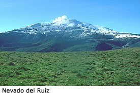
the northern end of this park is Nevado del Ruiz (5,389m) the highest
most active volcano in Colombia, while at the southern end is Nevada del
Tolima (5,215m.) Located between them are two other volcanoes: Nevado
de Santa Isabel (4,930m) and Nevado Quindio (4,700m.) It is their relatively
easy road access that has drawn not only local climbers but mountaineers
from around the world and has made the traverse of all four peaks, which
takes about seven days to complete, a popular route.
However,
in a cluster located to the southwest of Bogota and known as Parque Nacional
Los Nevados is a chain of volcanoes that are probably the most popular
climbing area in Colombia as well as a popular ski spot in winter. At
the northern end of this park is Nevado del Ruiz (5,389m) the highest
most active volcano in Colombia, while at the southern end is Nevada del
Tolima (5,215m.) Located between them are two other volcanoes: Nevado
de Santa Isabel (4,930m) and Nevado Quindio (4,700m.) It is their relatively
easy road access that has drawn not only local climbers but mountaineers
from around the world and has made the traverse of all four peaks, which
takes about seven days to complete, a popular route.
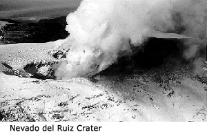
But it is not just the climbing that has made these mountains famous. On November 13, 1985, at 9:08 p.m. a catastrophic event took place that made headlines around the world when Nevado del Ruiz erupted. Within four hours of the beginning of the eruption, lahars had traveled one hundred kilometres and left behind a wake of destruction: more than 23,000 people were killed, about 5,000 injured, and more than 5,000 homes destroyed along the Chinchiná, Gualí, and Lagunillas Rivers. Hardest hit was the town of Armero at the mouth of the Río Lagunillas canyon. Three quarters of its 28,700 inhabitants perished.
 Earlier
eruptions of Nevado del Ruiz occurred in 1595 and again in 1845 and it
is known the eruptions melted snow and ice and produced mudflows that
travelled many kilometres from the volcano. These mudflows were confined
to the valleys that drain the volcano and caused no deaths. However, beginning
in November 1984, Nevado del Ruiz began showing clear signs of unrest
again, including earthquakes, increased fumarolic activity from the summit
crater, and small phreatic (steam) explosions. Scientists watched the
mountain for the next year but were unable to predict the eruption that
sent a series of pyroclastic flows and surges across the volcanoes broad
ice-covered summit. Within minutes, pumice and ash began to fall to the
northeast along with heavy rain that had started earlier in the day. The
crater was enlarged slightly by the eruption, and the summit area was
quickly covered with layers of pyroclastic flow deposits as thick as eight
metres.
Earlier
eruptions of Nevado del Ruiz occurred in 1595 and again in 1845 and it
is known the eruptions melted snow and ice and produced mudflows that
travelled many kilometres from the volcano. These mudflows were confined
to the valleys that drain the volcano and caused no deaths. However, beginning
in November 1984, Nevado del Ruiz began showing clear signs of unrest
again, including earthquakes, increased fumarolic activity from the summit
crater, and small phreatic (steam) explosions. Scientists watched the
mountain for the next year but were unable to predict the eruption that
sent a series of pyroclastic flows and surges across the volcanoes broad
ice-covered summit. Within minutes, pumice and ash began to fall to the
northeast along with heavy rain that had started earlier in the day. The
crater was enlarged slightly by the eruption, and the summit area was
quickly covered with layers of pyroclastic flow deposits as thick as eight
metres.
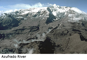 Hot
rock fragments of the pyroclastic flows and surges quickly eroded and
mixed with Ruiz's snow and ice, melting about ten percent of the volcanoes
ice cover. In places, channels one hundred metres wide and two to four
metres deep were eroded into the icecap. Flowing mixtures of water, ice,
pumice and other rock debris then descended several thousand metres from
the summit and sides of the volcano as a series of small lahars into the
six major river valleys draining the volcano. In one river, the Azufrado,
scientists found a piece of ice two metres across about three kilometres
from the crater.
Hot
rock fragments of the pyroclastic flows and surges quickly eroded and
mixed with Ruiz's snow and ice, melting about ten percent of the volcanoes
ice cover. In places, channels one hundred metres wide and two to four
metres deep were eroded into the icecap. Flowing mixtures of water, ice,
pumice and other rock debris then descended several thousand metres from
the summit and sides of the volcano as a series of small lahars into the
six major river valleys draining the volcano. In one river, the Azufrado,
scientists found a piece of ice two metres across about three kilometres
from the crater.
In the Guali River valley lahars travelled down at an average speed of sixty kilometres per hour and some were as thick as fifty metres. By incorporating water and debris from along river channels, the lahars grew in size as they moved away from the volcano. Some lahars increased up to four times their initial volumes as they eroded soil, loose rock debris and stripped vegetation from the river channels. This eruption of Nevado del Ruiz was the second mostly deadly of the twentieth century (Mount Pelee in Martinique was first, killing 29,000 people in its 1902 eruption.) It is believed that one tenth of the world's population live within the danger zone of volcanoes.
When Geoff Mahan and I arrived in Ibaque in September, 1988 after having climbed Volcán Puracé a few days before we decided to climb one of the volcanoes in Los Nevados. My friend Mario La Rotta, who we were staying with, introduced us to Manolo Barrios, a local mountain guide, who was able to give directions on how to get to Nevado del Tolima (the closest mountain to Ibaque) and a route description. We spent the next day rock climbing at Chicoral under a blistering equatorial sun and then returned to Ibaque to organize what we would need for the climb.
Sunday morning (4th) we were up early and got a taxi down to Cooperativa Velotax where we could get a ride with the local milk truck (Lechera) to the end of the road at El Silencio. The crowded ride on the milk truck took two took hours as we passed through lush tropical jungle: the sound of exotic birds being drowned out by rattling milk crates.
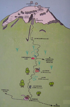 From
El Silencio we had a two kilometre walk to the hot springs at El Rancho
where the climbing began. Initially the trail was steep and muddy as it
followed a creek bed but it gradually eased off as we got near La Cascada
(The Waterfall) at around 3,000 metres. At this point we entered the mist
and were unable to see anything until we arrived at La Cueva (The Cave)
at 3,720 metres, four hours after leaving El Rancho. Here we found a rather
dilapidated hut perched under an overhang beside a small waterfall. That
afternoon we sat outside soaking up the sun as it periodically broke though
the mist. Occasionally we got a view of the route towards the summit and
it looked a long way. That night the noise of the waterfall nearby sounded
like a torrential downpour outside and I pulled the hood on my sleeping
bag tighter around my head to dampen the roar.
From
El Silencio we had a two kilometre walk to the hot springs at El Rancho
where the climbing began. Initially the trail was steep and muddy as it
followed a creek bed but it gradually eased off as we got near La Cascada
(The Waterfall) at around 3,000 metres. At this point we entered the mist
and were unable to see anything until we arrived at La Cueva (The Cave)
at 3,720 metres, four hours after leaving El Rancho. Here we found a rather
dilapidated hut perched under an overhang beside a small waterfall. That
afternoon we sat outside soaking up the sun as it periodically broke though
the mist. Occasionally we got a view of the route towards the summit and
it looked a long way. That night the noise of the waterfall nearby sounded
like a torrential downpour outside and I pulled the hood on my sleeping
bag tighter around my head to dampen the roar.
The next morning my alarm went off at 3:20 A.M., however, since the thick
fog still hadn't lifted we decided to curl up for another couple of hours.
We finally got up at 5:30 and were away by 6:15. For the next two and
a half hours we climbed through the Frailejon (Grey Friars) forest until
we hit the snowline just below the place called Latas. Here the hard work
began! Above us we could just pick out the black rocks of Cerro Negro
and La Canaleta (The Canal)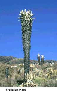 that ascends to the right of Cerro Negro, however, we had to plough through
snow knee deep to thigh deep that was physically taxing and time consuming.
Conditions remained misty and only brief clearances showed us we were
getting close to Cerro Negro. Time ticked by as we took turns breaking
the trail while the crust layer on top of the snow punched into our shins
with every step. A pair of soccer shin splints would have been handy at
this point! At the top of La Canaleta we continued straight up to the
crater. Here we roped up as the lighting was flat and we were unable to
see any definition on the snow. We hadn't seen any crevasses but Manolo
had warned us that they were around. We circumvented the crater to the
left and moved over low angled snow slopes to the rounded summit of Nevada
del Tolima. It had taken us six hours from La Cueva to the summit and
three and a half of those hours were on the soft snow on the last seven
hundred metres. However, standing on the mist-shrouded summit still seemed
worth the effort.
that ascends to the right of Cerro Negro, however, we had to plough through
snow knee deep to thigh deep that was physically taxing and time consuming.
Conditions remained misty and only brief clearances showed us we were
getting close to Cerro Negro. Time ticked by as we took turns breaking
the trail while the crust layer on top of the snow punched into our shins
with every step. A pair of soccer shin splints would have been handy at
this point! At the top of La Canaleta we continued straight up to the
crater. Here we roped up as the lighting was flat and we were unable to
see any definition on the snow. We hadn't seen any crevasses but Manolo
had warned us that they were around. We circumvented the crater to the
left and moved over low angled snow slopes to the rounded summit of Nevada
del Tolima. It had taken us six hours from La Cueva to the summit and
three and a half of those hours were on the soft snow on the last seven
hundred metres. However, standing on the mist-shrouded summit still seemed
worth the effort.
After ten minutes we realised there was no point in hanging around too long on the summit as it was obvious the mist wasn't going to clear. The descent was just as tiring as the ascent and we were glad to finally get off the snow and onto solid terra firma. By 2:30 P.M. Geoff and I arrived exhausted back at the little hut and had a late lunch and then spent the rest of the afternoon relaxing.
That night I slept the sleep of the dead and felt fully refreshed the next morning when I woke up. Geoff and I left La Cueva at 6:10 A.M. and arrived down at El Rancho an hour and three quarters later, a little muddy and damp with sweat. We hiked briskly the two kilometres to El Silencio and then we had an hour and a half to dry our damp gear in the sun before getting a ride on the milk truck back to Ibaque. The return trip taking longer than the ride in as the truck had to stop and pick up milk from the local farmers along the way.
Back in Ibaque we looked over some of Manolo's slides of the Los Nevados volcanoes. We would love to have spent more time in these mountains and complete the traverse over the other summits to Nevado del Ruiz, unfortunately we were running out of time as we wanted to get to the Mexican volcanoes.
Since 1985 the Colombian volcanoes have been relatively quiet, however, global warming has affected the mountains as the glaciers have shrunk significantly due to a decrease in the annual snowfall. In a report called "Thawing of the Peaks" by the Director of the Colombian government Institute of Hydrology, Meteorology and Environmental Studies it has been announced that water reservoirs around the central mountains could be dramatically reduced in the next one hundred years as the amount of accumulated snow decreases and runoff is reduced. This will affect the lives of those living on the rich soil surrounding the volcanoes. This had become evident not only on the mountains of Colombia but around the world and is a growing problem.
The volcanoes of Nevado del Ruiz and Nevada del Tolima in Parque Nacional Los Nevados in central Colombia are beautiful mountains and should not be dismissed by climbers visiting South America. Yes, Colombia is a violent country if we listen to the news but the people are friendly and the scenery spectacular. I left Colombia with the knowledge that one day I would return and in a little café in a mountain village savour a revitalizing cup of Juan Valdez's coffee while experiencing the high of climbing another beautiful mountain.
How to order | | About the Author || Links || Home
Contact:
Copyright ©
Lindsay Elms 2001. All Rights Reserved.
URL: http://www.beyondnootka.com
http://www.lindsayelms.ca