Island Stories:
![]() Danzig
Mine
Danzig
Mine
![]() Zeballos
Iron Mine
Zeballos
Iron Mine
![]() Conuma
Peak 1910
Conuma
Peak 1910
Alexandra Peak
Argus Mountain
Bate/Alava Sanctuary
Beaufort Range
Big Interior Mtn
Big Interior Mtn 1913
Part 1
Part 2
Bolton Expedition 1896
Cliffe Glacier
Clinton Wood
Comox Glacier
Comox Glacier 1922
Comox Glacier 1925
Comstock Mtn
Conuma Peak
Copper King Mine
Crown Mtn
Elkhorn 1912
Elkhorn 1949
Elkhorn 1968
Eugene Croteau
Golden Bullets
Golden Hinde 1913/14
Golden Hinde 1937
Golden Hinde 1983
Harry Winstone Tragedy
Jack Mitchell
Jim Mitchell Tragedy
John Buttle
Judges Route
Koksilah's Silver Mine
Landslide Lake
Mackenzie Range
Malaspina Peak
Mariner Mtn
Marjories Load
Matchlee Mountain
Mount McQuillan
Mt. Albert Edward
Mt. Albert Edward 1927
Mt. Albert Edward 1938
Mt. Becher
Mt. Benson 1913
Mt. Benson
Mt. Doogie Dowler
Mt. Colonel Foster
Mt. Hayes/Thistle Claim
Mt. Maxwell
Mt. Sicker
Mt. Tzouhalem
Mt. Whymper
Muqin/Brooks Peninsula
Nine Peaks
Queneesh
Ralph Rosseau 1947
Rosseau Chalet
Ralph Rosseau Tragedy
Rambler Peak
Red Pillar
Rex Gibson Tragedy
Sid's Cabin
Steamboat Mtn
Strathcona Park 1980's
The Misthorns
The Unwild Side
Victoria Peak
Waterloo Mountain 1865
Wheaton Hut/Marble Meadows
William DeVoe
Woss Lake
You Creek Mine
Zeballos Peak
Other Stories:
Sierra
de los Tuxtlas
Antarctica
Cerro del Tepozteco
Citlaltepetl
Huascaran
Mt. Roraima
Nevada Alpamayo
Nevada del Tolima
Nevado de Toluca
Pico Bolivar
Popocatepetl
Uluru/Ayers Rock
Volcan Purace
Volcan San Jose
Biographies
Island 6000
Cartoons
Order the Book
Contact Me
Links

The Mackenzie
Range:
Challenges of the Lesser Known Mountains
by Lindsay Elms
Spectacular alpine scenery is not in short supply on Vancouver Island and there are enough mountains to keep climbing enthusiasts busy for a lifetime. However, when compared to the Rockies and Coast Mountains of British Columbia that rise upwards of 4,000 metres, Vancouver Island's Alps appear insignificant as they reach a maximum elevation of 2,200 metres. Fortunately, local mountaineers have learned that their lack of height doesn't make them any less challenging.
 Over
the last one hundred years a few of the greatest mountaineers in the world
have sought to climb on Vancouver Island. In the early 1900's the Canadian
Pacific Railway (CPR) brought British mountaineer Edward Whymper out to
promote mountaineering in the Rockies. Whymper, who had led the successful
attack on the Matterhorn in 1865, is rumoured to have climbed Mount Arrowsmith,
which at the time was thought to be the highest peak on the island. Vancouver
Island was still relatively unexplored at that time and little was known
about the interior peaks. As time went by the heart of the island was
soon to prove to be a mecca for climbing. All the big peaks saw numerous
ascents by the traditional ridges but as climbing techniques and equipment
developed mountaineers began looking for more difficult routes up the
larger, steeper faces.
Over
the last one hundred years a few of the greatest mountaineers in the world
have sought to climb on Vancouver Island. In the early 1900's the Canadian
Pacific Railway (CPR) brought British mountaineer Edward Whymper out to
promote mountaineering in the Rockies. Whymper, who had led the successful
attack on the Matterhorn in 1865, is rumoured to have climbed Mount Arrowsmith,
which at the time was thought to be the highest peak on the island. Vancouver
Island was still relatively unexplored at that time and little was known
about the interior peaks. As time went by the heart of the island was
soon to prove to be a mecca for climbing. All the big peaks saw numerous
ascents by the traditional ridges but as climbing techniques and equipment
developed mountaineers began looking for more difficult routes up the
larger, steeper faces.
In the late 1980's Britain's Doug Scott and Australia's Greg Child teamed up with local mountaineer Rob Wood to climb the one thousand metre East Face of Mount Colonel Foster. Scott and Child were both proven technical and high altitude climbers with ascents of new routes on the two highest mountains in the world: Mount Everest and K2. Their winter ascent of Mount Colonel Foster put climbing on Vancouver Island in the international limelight. For three days they struggled up the East Face until they reached the summit. Scott wrote: "It's remote here and there aren't the facilities. The challenges are comparable with anywhere else …"
However, as with anywhere in the world, there are mountaineers seeking adventure on the less known mountains and, in the scheme of things, having fun at the same time. Vancouver Island has numerous peaks that fit this criterior: what they lack in height they make up for in climbing quality and visual aesthetics.
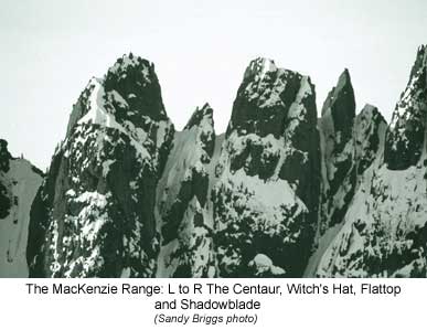
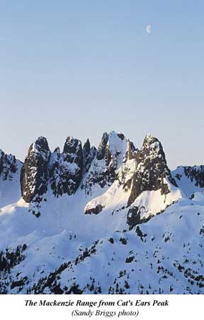
One such mountain range towers above Highway 4 between Port Alberni and Long Beach as a series of steep and rugged spires collectively called the Mackenzie Range. On clear days fleeting glimpses of glistening rock and crystalline ice towers perch menacingly above the thick bush and heavily timbered forest of the Kennedy River. It is this thick bush that in fact makes for a unique breed of climber who revels in the perverse pleasure of battling the primeval vegetation on the approach to the mountain. With the rainfall measured in metres on the West Coast, the temperate rainforest continuously drips with moisture for most of the year only briefly drying out in the summer months. Vegetation is thick and luxurious and any sign of passage is quickly consumed. For climbers who undertake the "bushwhack" to the alpine a beautiful playground is unfolded.
Although early coastal navigators could see the craggy range from Barkley Sound, little interest in the mountains took place until the lure of gold sent prospectors scrambling into the unknown valleys in the late 1800's and early 1900's. Although they climbed high onto some of the surrounding mountains, it was the valleys that were of more interest.
Geologically, the area consists mainly of the volcanic basalts and breccias of the Karmutsen Formation, the oldest, thickest and most widespread formation on the island found on Triple Peak, The Cat's Ears and the Mackenzie Range. Lesser areas of granodiorite and quartz-diorite belonging to the relatively young Island Intrusion Formation are found interspersed with the former, with minor intrusions of andesite breccia and argillite of the Volcanic Division of the Bonanza Subgroup. A few areas of massive limestone belonging to the Quatsino Formation overlying the older Karmutsen Formation are also found in the region, most noticeably on Steamboat Mountain and 5040 Peak. It was in the granodiorite and quartz-diorite that the prospectors pinned their hopes of finding the mother-lode. Although many claims were staked, none were to prove financially viable.
It wasn't until 1941 that many of the more accessible summits surrounding the Kennedy River were finally climbed. Robert McCaw and George Jackson were both noted British Columbia Land Surveyors. Their job was to take triangulation readings of the mountains and valleys from survey stations located, in many instances, on the summits of the surrounding peaks. This information was transferred to paper and was eventually drawn up in the form of topographical maps of the area. However, the summits such as Triple Peak, The Cat's Ears and the Mackenzie Range remained unclimbed due to their rugged nature.
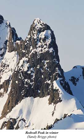
The first record of climbers visiting the Mackenzie Range was in 1960 when Dick Culbert and T. Stevens climbed Redwell Peak via the Northwest Ridge. Redwall being the prominent peak seen from the highway below. Culbert went on to became an authority on the mountains of the west coast writing the Alpine Guide to Southwestern British Columbia and A Climbers Guide to the Coast Range of British Columbia. A talent climber himself, he undertook the first ascent of the 1,000 metre East Face of Mount Colonel Foster on Vancouver Island in 1972.
 However,
it wasn't until the late 1960's that climbers from the Island Mountain
Ramblers of Nanaimo and the Vancouver Island Section of the Alpine Club
of Canada became interested in these spectacular peaks. Both clubs had
a number of climbers who were pushing the limits and achieving astonishing
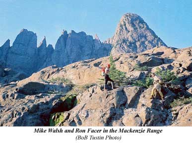
results from their bold climbs. Over the Labour Day weekend of 1967 Bob
Tustin, Mike Walsh and Ron Facer visited the MacKenzie
Range for the first time via Canoe Creek to the east of the range. After
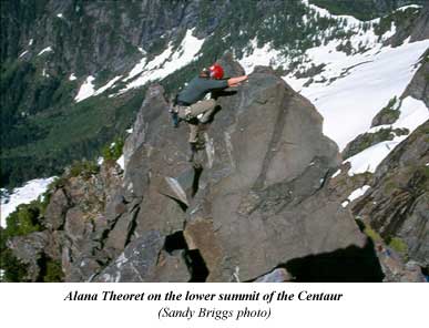
traversing around under Redwall Peak Walsh and Facer climbed the Witch's
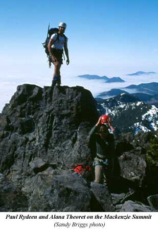
Hat and The Centaur via a steep gully system from the west. In 1968 Patrick
Guilbride and Syd
Watts went into the range and climbed the Mackenzie Summit
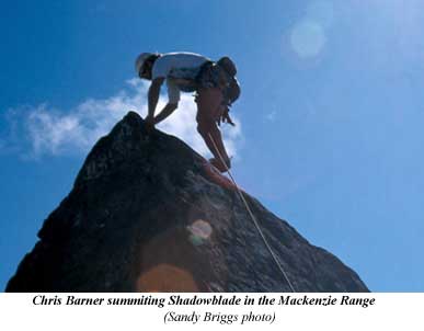
and then in 1972 Mike Walsh returned with Bill
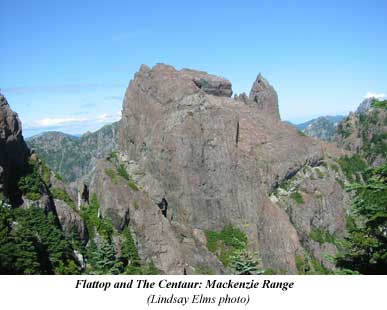
Perry and climbed Shadowblade, the sharp spike between the
Mackenzie Summit and Flat-top. Both Walsh and Perry were extremely competent
on rock and made numerous forays onto some of the island's bigger mountains:
Walsh made the first ascent of the main summit of Mount Colonel Foster
(solo) and the first traverse of the mountain with Perry.
However,
it wasn't until the late 1960's that climbers from the Island Mountain
Ramblers of Nanaimo and the Vancouver Island Section of the Alpine Club
of Canada became interested in these spectacular peaks. Both clubs had
a number of climbers who were pushing the limits and achieving astonishing
results from their bold climbs. Over the Labour Day weekend of 1967 Bob
Tustin, Mike Walsh and Ron Facer visited the MacKenzie
Range for the first time via Canoe Creek to the east of the range. After
traversing around under Redwall Peak Walsh and Facer climbed the Witch's
Hat and The Centaur via a steep gully system from the west. In 1968 Patrick
Guilbride and Syd
Watts went into the range and climbed the Mackenzie Summit
and then in 1972 Mike Walsh returned with Bill
Perry and climbed Shadowblade, the sharp spike between the
Mackenzie Summit and Flat-top. Both Walsh and Perry were extremely competent
on rock and made numerous forays onto some of the island's bigger mountains:
Walsh made the first ascent of the main summit of Mount Colonel Foster
(solo) and the first traverse of the mountain with Perry.
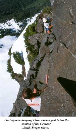
On July 31, 1977, Bill Perry returned to the range with Al Harrison, Nicki Westarp, Tom Emerson and two others from Victoria. They spent six hours slogging up through wet bush to the timberline, where: "… a welcome sun broke thru the mist, turning the meadows suddenly and brilliantly to the most idealized vision of a mountain landscape." After setting up camp on top of what they called "False Peak" now unofficially called Perez Lookout, Perry and Westarp climbed the Mackenzie Summit while Harrison and Emerson climbed Redwall Peak.
The next day (Aug. 1), the two from Victoria attempted Redwall Peak while Perry, Emerson and Harrison left for Flat-top, the last unclimbed summit in the range. After seventy to ninety metres of climbing up a class 3 gully they reached the narrow notch between Shadowblade and Flat-top. Harrison led the vertical section and then belayed Perry up the easy summit friction pitch. Emerson deciding that the difficult moves and the exposure were too much for him. From the top Harrison and Perry had the usual superb views over Toquart Bay and the west coast. After returning to camp and resting for a while they finished the long hot descent to the highway and their vehicle with daylight to spare.
Perry wrote: "A highlight of the trip was returning to camp [after climbing the Mackenzie Summit] - the whole scene bathed in the most outrageous sunset - silhouetting the Maitlands [Mount Maitland and Hidden Peak] - flooding everything in a hushed, purple glow, to contemplate and savor, then and now."
 Throughout
the 1980 and 1990's a core of climbers from the local Alpine Club of Canada
worked on a trail to access this alpine playground. It has sped the approach
time to reach the alpine significantly and made the peaks more feasible
as day trips. This in turn has given access for those interested in attempting
new routes on some of the peaks. Recently some of the strongest technical
climbers on the island have made the pilgrimage to the area.
Throughout
the 1980 and 1990's a core of climbers from the local Alpine Club of Canada
worked on a trail to access this alpine playground. It has sped the approach
time to reach the alpine significantly and made the peaks more feasible
as day trips. This in turn has given access for those interested in attempting
new routes on some of the peaks. Recently some of the strongest technical
climbers on the island have made the pilgrimage to the area.
On Sept. 21, 2003, Cumberland climbers John Waters and Aaron Hamilton (two climbers who have been pioneering complex routes on Mount Colonel Foster and Mount Tom Taylor as well as the development of the Comox Lake Crags) visited the Mackenzie Range for the first time and put up a new route on the North Face of Redwall Peak. This four hundred and twenty-five metre, eight pitch route was given a grade of 5.9 while further to the right on the same day two others Rob Grant and Greg Killops were putting up another route, "Turtle Heads and Gophers," that went at 5.10. These routes, although not sustained at that grade, still give a sense of the quality of rock in this range of mountains and the potential.
The dramatic spires of the Mackenzie Range are drawing both the recreational climber and the climber interested in short technical routes on good solid rock. Over the years familiar names have kept cropping up in the summit registers on the peaks and the climbing reports in the Vancouver Island Bushwhacker are always glowing. There are still numerous challenging routes existing on the islands lesser mountains for the mountaineer who is prepared to undertake the steep primeval bushwhack to the alpine. The Mackenzie Range is just one of those areas where a spectacular playground exists.
 |
 |
 |
 |
 |
 |
How to order | | About the Author || Links || Home
Contact:
Copyright ©
Lindsay Elms 2001. All Rights Reserved.
URL: http://www.beyondnootka.com
http://www.lindsayelms.ca